You are here: Home > Network List > IU - Global Seismograph Network (GSN - IRIS/USGS) Stations List
> Station RSSD Black Hills, South Dakota, USA > Earthquake Result Viewer
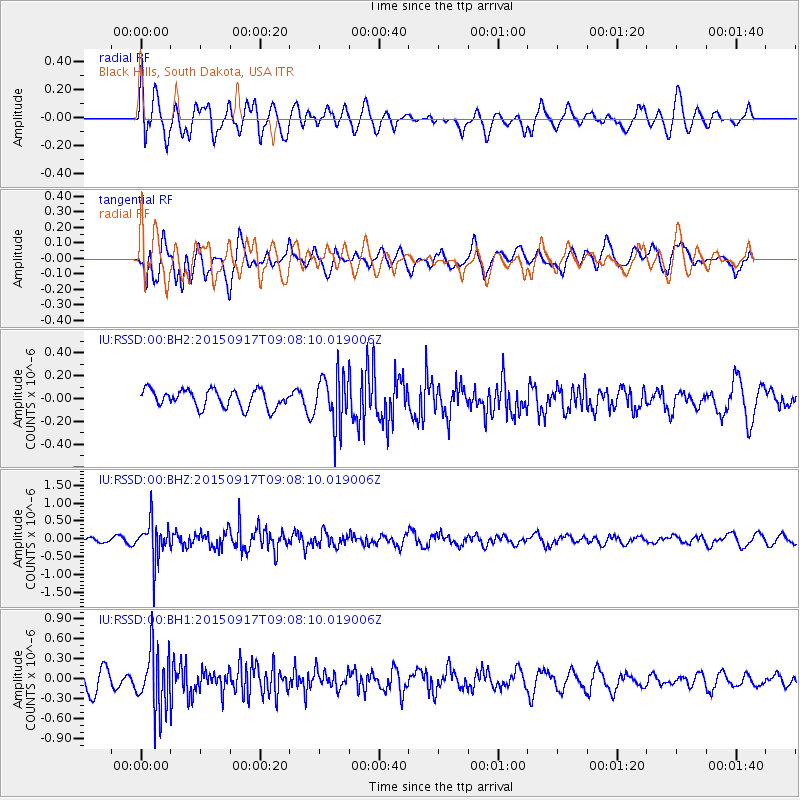
RSSD Black Hills, South Dakota, USA - Earthquake Result Viewer
*The percent match for this event was below the threshold and hence no stack was calculated.
| Earthquake location: |
Near East Coast Of Kamchatka |
| Earthquake latitude/longitude: |
53.3/159.7 |
| Earthquake time(UTC): |
2015/09/17 (260) 08:58:44 GMT |
| Earthquake Depth: |
69 km |
| Earthquake Magnitude: |
5.5 MB |
| Earthquake Catalog/Contributor: |
NEIC PDE/NEIC COMCAT |
|
| Network: |
IU Global Seismograph Network (GSN - IRIS/USGS) |
| Station: |
RSSD Black Hills, South Dakota, USA |
| Lat/Lon: |
44.12 N/104.04 W |
| Elevation: |
2090 m |
|
| Distance: |
59.5 deg |
| Az: |
56.205 deg |
| Baz: |
316.162 deg |
| Ray Param: |
$rayparam |
*The percent match for this event was below the threshold and hence was not used in the summary stack. |
|
| Radial Match: |
57.346256 % |
| Radial Bump: |
400 |
| Transverse Match: |
63.441357 % |
| Transverse Bump: |
400 |
| SOD ConfigId: |
1156111 |
| Insert Time: |
2015-10-07 07:29:05.272 +0000 |
| GWidth: |
2.5 |
| Max Bumps: |
400 |
| Tol: |
0.001 |
|
Signal To Noise
| Channel | StoN | STA | LTA |
| IU:RSSD:00:BHZ:20150917T09:08:10.019006Z | 5.925749 | 5.452655E-7 | 9.20163E-8 |
| IU:RSSD:00:BH1:20150917T09:08:10.019006Z | 2.9382162 | 4.5227847E-7 | 1.539296E-7 |
| IU:RSSD:00:BH2:20150917T09:08:10.019006Z | 2.818582 | 2.1973483E-7 | 7.795935E-8 |
| Arrivals |
| Ps | |
| PpPs | |
| PsPs/PpSs | |


