You are here: Home > Network List > US - United States National Seismic Network Stations List
> Station LTX Lajitas, Texas, USA > Earthquake Result Viewer
LTX Lajitas, Texas, USA - Earthquake Result Viewer
| Earthquake location: |
Southeast Of Honshu, Japan |
| Earthquake latitude/longitude: |
33.9/139.4 |
| Earthquake time(UTC): |
2000/07/30 (212) 12:25:45 GMT |
| Earthquake Depth: |
10 km |
| Earthquake Magnitude: |
6.0 MB, 6.5 MS, 6.5 MW, 6.5 MW |
| Earthquake Catalog/Contributor: |
WHDF/NEIC |
|
| Network: |
US United States National Seismic Network |
| Station: |
LTX Lajitas, Texas, USA |
| Lat/Lon: |
29.33 N/103.67 W |
| Elevation: |
1013 m |
|
| Distance: |
93.4 deg |
| Az: |
51.228 deg |
| Baz: |
312.043 deg |
| Ray Param: |
0.0412759 |
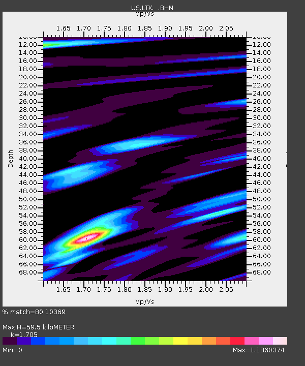
| Estimated Moho Depth: |
59.5 km |
| Estimated Crust Vp/Vs: |
1.71 |
| Assumed Crust Vp: |
6.419 km/s |
| Estimated Crust Vs: |
3.765 km/s |
| Estimated Crust Poisson's Ratio: |
0.24 |
|
| Radial Match: |
80.10369 % |
| Radial Bump: |
400 |
| Transverse Match: |
73.133545 % |
| Transverse Bump: |
400 |
| SOD ConfigId: |
110165 |
| Insert Time: |
2010-03-05 07:03:02.121 +0000 |
| GWidth: |
2.5 |
| Max Bumps: |
400 |
| Tol: |
0.001 |
|
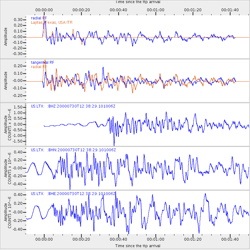
Signal To Noise
| Channel | StoN | STA | LTA |
| US:LTX: :BHN:20000730T12:38:29.101006Z | 1.6510274 | 1.0157909E-7 | 6.152477E-8 |
| US:LTX: :BHE:20000730T12:38:29.101006Z | 1.2806408 | 1.1579016E-7 | 9.0415796E-8 |
| US:LTX: :BHZ:20000730T12:38:29.101006Z | 2.1910846 | 1.8187755E-7 | 8.3008004E-8 |
| Arrivals |
| Ps | 6.7 SECOND |
| PpPs | 25 SECOND |
| PsPs/PpSs | 31 SECOND |


