You are here: Home > Network List > US - United States National Seismic Network Stations List
> Station LTX Lajitas, Texas, USA > Earthquake Result Viewer
LTX Lajitas, Texas, USA - Earthquake Result Viewer
| Earthquake location: |
South Pacific Ocean |
| Earthquake latitude/longitude: |
-44.4/-117.4 |
| Earthquake time(UTC): |
2000/03/15 (075) 06:35:05 GMT |
| Earthquake Depth: |
10 km |
| Earthquake Magnitude: |
5.9 MB, 5.5 MS, 5.9 MW |
| Earthquake Catalog/Contributor: |
WHDF/NEIC |
|
| Network: |
US United States National Seismic Network |
| Station: |
LTX Lajitas, Texas, USA |
| Lat/Lon: |
29.33 N/103.67 W |
| Elevation: |
1013 m |
|
| Distance: |
74.4 deg |
| Az: |
12.457 deg |
| Baz: |
190.201 deg |
| Ray Param: |
0.052328136 |
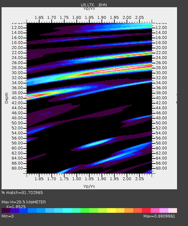
| Estimated Moho Depth: |
28.5 km |
| Estimated Crust Vp/Vs: |
1.95 |
| Assumed Crust Vp: |
6.419 km/s |
| Estimated Crust Vs: |
3.288 km/s |
| Estimated Crust Poisson's Ratio: |
0.32 |
|
| Radial Match: |
81.702965 % |
| Radial Bump: |
387 |
| Transverse Match: |
64.34137 % |
| Transverse Bump: |
400 |
| SOD ConfigId: |
110165 |
| Insert Time: |
2010-03-05 07:03:11.841 +0000 |
| GWidth: |
2.5 |
| Max Bumps: |
400 |
| Tol: |
0.001 |
|
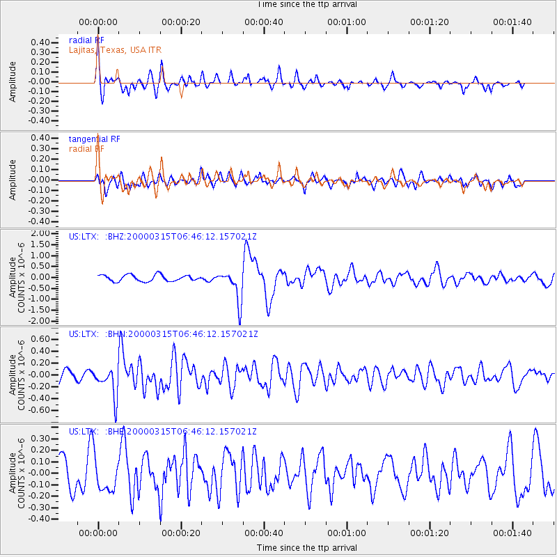
Signal To Noise
| Channel | StoN | STA | LTA |
| US:LTX: :BHN:20000315T06:46:12.157021Z | 2.3891854 | 2.5493432E-7 | 1.0670345E-7 |
| US:LTX: :BHE:20000315T06:46:12.157021Z | 0.7457836 | 1.2637105E-7 | 1.6944735E-7 |
| US:LTX: :BHZ:20000315T06:46:12.157021Z | 5.257204 | 7.582302E-7 | 1.4422689E-7 |
| Arrivals |
| Ps | 4.4 SECOND |
| PpPs | 13 SECOND |
| PsPs/PpSs | 17 SECOND |


