You are here: Home > Network List > US - United States National Seismic Network Stations List
> Station LTX Lajitas, Texas, USA > Earthquake Result Viewer
LTX Lajitas, Texas, USA - Earthquake Result Viewer
| Earthquake location: |
Panama |
| Earthquake latitude/longitude: |
9.4/-78.5 |
| Earthquake time(UTC): |
2000/02/26 (057) 18:24:39 GMT |
| Earthquake Depth: |
65 km |
| Earthquake Magnitude: |
5.8 MB, 5.4 MS, 6.2 MW, 6.1 MW |
| Earthquake Catalog/Contributor: |
WHDF/NEIC |
|
| Network: |
US United States National Seismic Network |
| Station: |
LTX Lajitas, Texas, USA |
| Lat/Lon: |
29.33 N/103.67 W |
| Elevation: |
1013 m |
|
| Distance: |
30.8 deg |
| Az: |
313.551 deg |
| Baz: |
125.014 deg |
| Ray Param: |
0.0791489 |
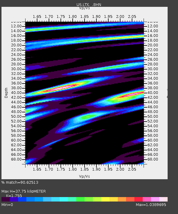
| Estimated Moho Depth: |
37.75 km |
| Estimated Crust Vp/Vs: |
1.75 |
| Assumed Crust Vp: |
6.419 km/s |
| Estimated Crust Vs: |
3.658 km/s |
| Estimated Crust Poisson's Ratio: |
0.26 |
|
| Radial Match: |
90.62513 % |
| Radial Bump: |
400 |
| Transverse Match: |
72.3214 % |
| Transverse Bump: |
400 |
| SOD ConfigId: |
110165 |
| Insert Time: |
2010-03-05 07:03:13.148 +0000 |
| GWidth: |
2.5 |
| Max Bumps: |
400 |
| Tol: |
0.001 |
|
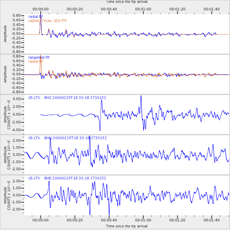
Signal To Noise
| Channel | StoN | STA | LTA |
| US:LTX: :BHN:20000226T18:30:18.373015Z | 1.9275248 | 3.5419654E-7 | 1.837572E-7 |
| US:LTX: :BHE:20000226T18:30:18.373015Z | 5.44031 | 5.121986E-7 | 9.414879E-8 |
| US:LTX: :BHZ:20000226T18:30:18.373015Z | 7.344113 | 1.0785667E-6 | 1.468614E-7 |
| Arrivals |
| Ps | 4.8 SECOND |
| PpPs | 15 SECOND |
| PsPs/PpSs | 20 SECOND |


