You are here: Home > Network List > US - United States National Seismic Network Stations List
> Station LTX Lajitas, Texas, USA > Earthquake Result Viewer
LTX Lajitas, Texas, USA - Earthquake Result Viewer
| Earthquake location: |
Vanuatu Islands |
| Earthquake latitude/longitude: |
-14.9/167.2 |
| Earthquake time(UTC): |
2001/01/09 (009) 16:49:28 GMT |
| Earthquake Depth: |
103 km |
| Earthquake Magnitude: |
6.3 MB, 6.6 MS, 7.6 ME, 7.0 MW |
| Earthquake Catalog/Contributor: |
WHDF/NEIC |
|
| Network: |
US United States National Seismic Network |
| Station: |
LTX Lajitas, Texas, USA |
| Lat/Lon: |
29.33 N/103.67 W |
| Elevation: |
1013 m |
|
| Distance: |
96.5 deg |
| Az: |
61.481 deg |
| Baz: |
256.592 deg |
| Ray Param: |
0.0404277 |
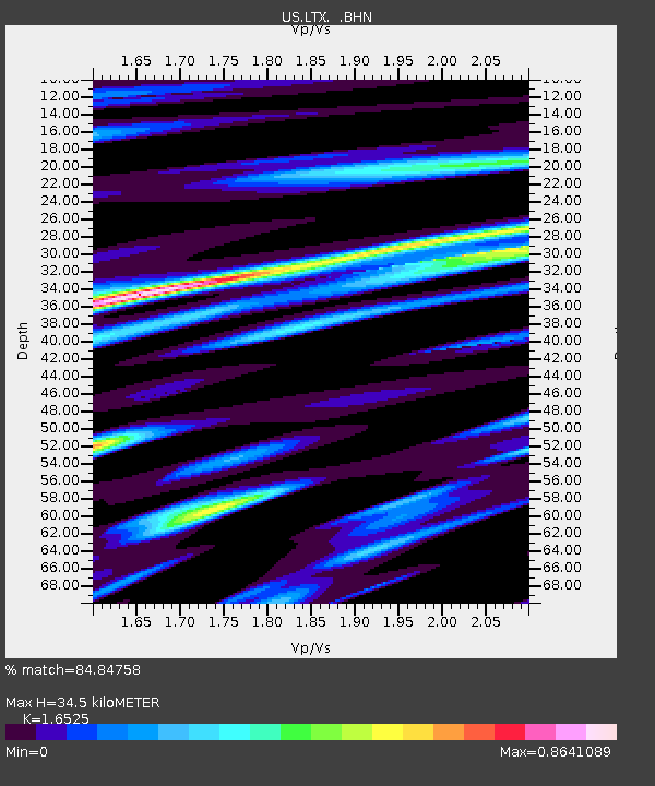
| Estimated Moho Depth: |
34.5 km |
| Estimated Crust Vp/Vs: |
1.65 |
| Assumed Crust Vp: |
6.419 km/s |
| Estimated Crust Vs: |
3.885 km/s |
| Estimated Crust Poisson's Ratio: |
0.21 |
|
| Radial Match: |
84.84758 % |
| Radial Bump: |
331 |
| Transverse Match: |
62.124638 % |
| Transverse Bump: |
400 |
| SOD ConfigId: |
20082 |
| Insert Time: |
2010-03-05 07:03:20.542 +0000 |
| GWidth: |
2.5 |
| Max Bumps: |
400 |
| Tol: |
0.001 |
|
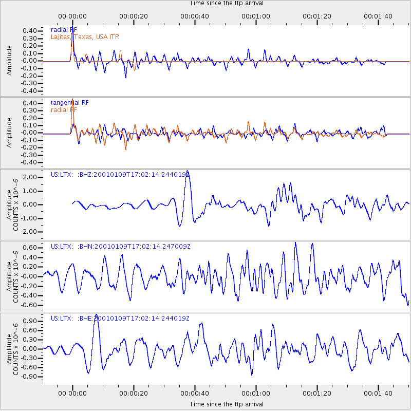
Signal To Noise
| Channel | StoN | STA | LTA |
| US:LTX: :BHN:20010109T17:02:14.247009Z | 0.95930916 | 2.0359278E-7 | 2.1222854E-7 |
| US:LTX: :BHE:20010109T17:02:14.244019Z | 1.8072053 | 2.3192351E-7 | 1.2833267E-7 |
| US:LTX: :BHZ:20010109T17:02:14.244019Z | 2.6073773 | 4.856714E-7 | 1.8626818E-7 |
| Arrivals |
| Ps | 3.6 SECOND |
| PpPs | 14 SECOND |
| PsPs/PpSs | 18 SECOND |


