You are here: Home > Network List > US - United States National Seismic Network Stations List
> Station LTX Lajitas, Texas, USA > Earthquake Result Viewer
LTX Lajitas, Texas, USA - Earthquake Result Viewer
| Earthquake location: |
Kuril Islands |
| Earthquake latitude/longitude: |
44.3/150.0 |
| Earthquake time(UTC): |
2002/10/19 (292) 12:09:05 GMT |
| Earthquake Depth: |
33 km |
| Earthquake Magnitude: |
5.4 MB, 6.2 MS, 6.4 MW, 6.1 MW |
| Earthquake Catalog/Contributor: |
WHDF/NEIC |
|
| Network: |
US United States National Seismic Network |
| Station: |
LTX Lajitas, Texas, USA |
| Lat/Lon: |
29.33 N/103.67 W |
| Elevation: |
1013 m |
|
| Distance: |
80.6 deg |
| Az: |
58.108 deg |
| Baz: |
315.715 deg |
| Ray Param: |
0.048088636 |
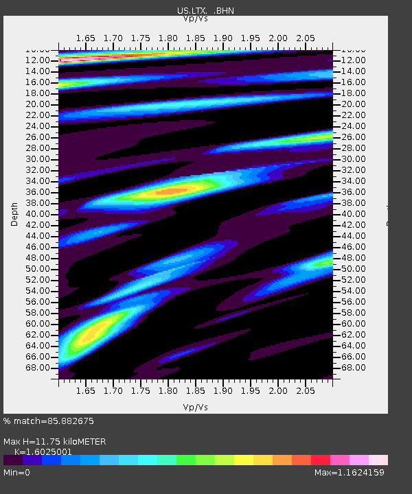
| Estimated Moho Depth: |
11.75 km |
| Estimated Crust Vp/Vs: |
1.60 |
| Assumed Crust Vp: |
6.419 km/s |
| Estimated Crust Vs: |
4.006 km/s |
| Estimated Crust Poisson's Ratio: |
0.18 |
|
| Radial Match: |
85.882675 % |
| Radial Bump: |
400 |
| Transverse Match: |
64.93223 % |
| Transverse Bump: |
400 |
| SOD ConfigId: |
110165 |
| Insert Time: |
2010-03-05 07:03:23.271 +0000 |
| GWidth: |
2.5 |
| Max Bumps: |
400 |
| Tol: |
0.001 |
|
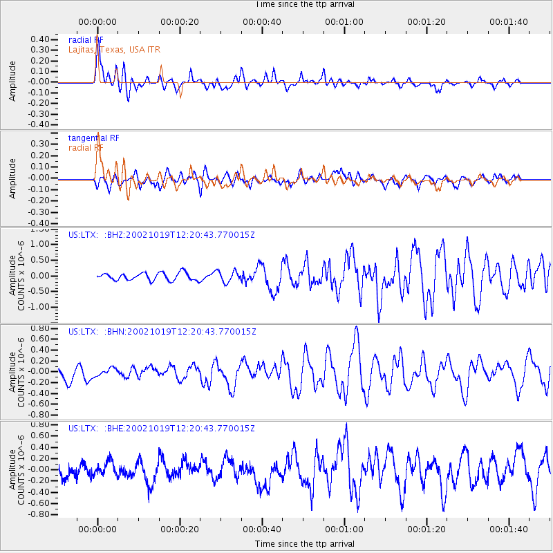
Signal To Noise
| Channel | StoN | STA | LTA |
| US:LTX: :BHN:20021019T12:20:43.770015Z | 0.6854269 | 7.189942E-8 | 1.0489729E-7 |
| US:LTX: :BHE:20021019T12:20:43.770015Z | 1.3135216 | 1.3500804E-7 | 1.0278327E-7 |
| US:LTX: :BHZ:20021019T12:20:43.770015Z | 1.4471374 | 1.7415454E-7 | 1.2034417E-7 |
| Arrivals |
| Ps | 1.1 SECOND |
| PpPs | 4.6 SECOND |
| PsPs/PpSs | 5.8 SECOND |


