You are here: Home > Network List > US - United States National Seismic Network Stations List
> Station LTX Lajitas, Texas, USA > Earthquake Result Viewer
LTX Lajitas, Texas, USA - Earthquake Result Viewer
| Earthquake location: |
Catamarca Province, Argentina |
| Earthquake latitude/longitude: |
-28.9/-66.8 |
| Earthquake time(UTC): |
2002/05/28 (148) 04:04:22 GMT |
| Earthquake Depth: |
22 km |
| Earthquake Magnitude: |
6.0 MB, 5.7 MS, 6.0 MW, 5.9 MW |
| Earthquake Catalog/Contributor: |
WHDF/NEIC |
|
| Network: |
US United States National Seismic Network |
| Station: |
LTX Lajitas, Texas, USA |
| Lat/Lon: |
29.33 N/103.67 W |
| Elevation: |
1013 m |
|
| Distance: |
67.8 deg |
| Az: |
325.541 deg |
| Baz: |
145.391 deg |
| Ray Param: |
0.05668805 |
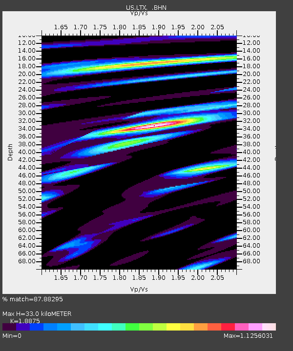
| Estimated Moho Depth: |
33.0 km |
| Estimated Crust Vp/Vs: |
1.89 |
| Assumed Crust Vp: |
6.419 km/s |
| Estimated Crust Vs: |
3.401 km/s |
| Estimated Crust Poisson's Ratio: |
0.30 |
|
| Radial Match: |
87.88295 % |
| Radial Bump: |
395 |
| Transverse Match: |
77.91062 % |
| Transverse Bump: |
400 |
| SOD ConfigId: |
110177 |
| Insert Time: |
2010-03-05 07:03:26.428 +0000 |
| GWidth: |
2.5 |
| Max Bumps: |
400 |
| Tol: |
0.001 |
|
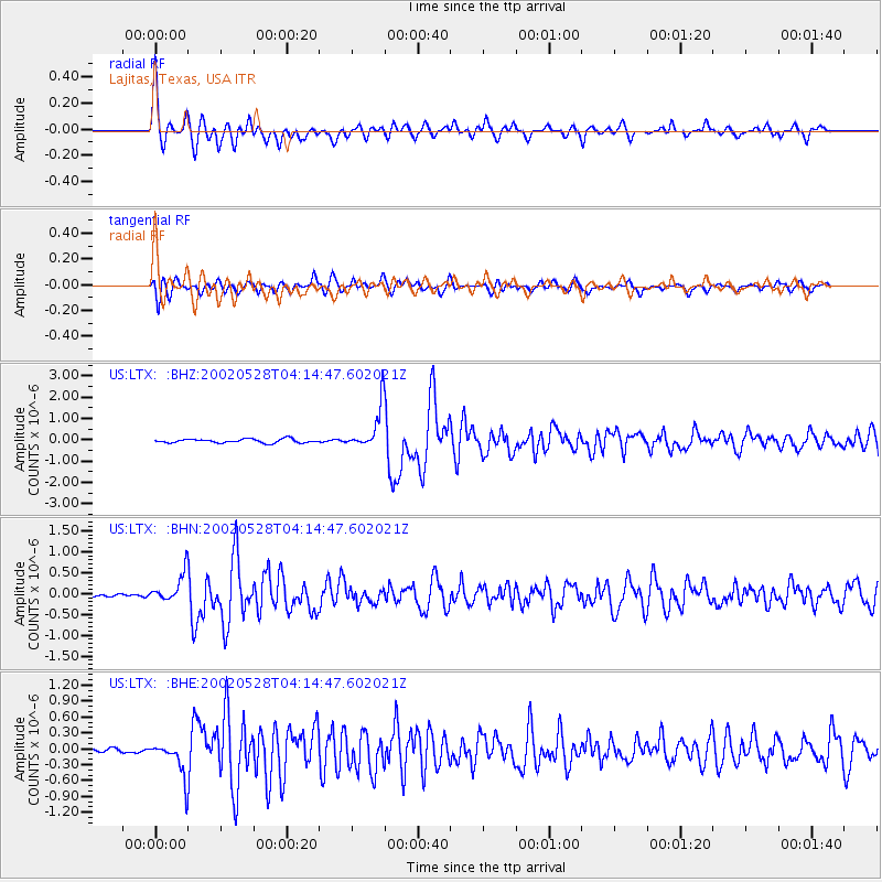
Signal To Noise
| Channel | StoN | STA | LTA |
| US:LTX: :BHN:20020528T04:14:47.602021Z | 5.4361377 | 3.402233E-7 | 6.2585485E-8 |
| US:LTX: :BHE:20020528T04:14:47.602021Z | 5.413813 | 3.2480585E-7 | 5.9995756E-8 |
| US:LTX: :BHZ:20020528T04:14:47.602021Z | 10.943199 | 9.992068E-7 | 9.130847E-8 |
| Arrivals |
| Ps | 4.7 SECOND |
| PpPs | 14 SECOND |
| PsPs/PpSs | 19 SECOND |


