You are here: Home > Network List > CN - Canadian National Seismograph Network Stations List
> Station INK INUVIK, NT > Earthquake Result Viewer
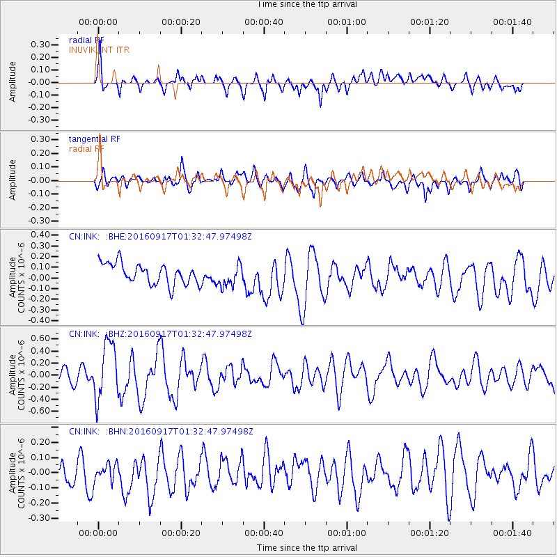
INK INUVIK, NT - Earthquake Result Viewer
*The percent match for this event was below the threshold and hence no stack was calculated.
| Earthquake location: |
Near North Coast Of Irian Jaya |
| Earthquake latitude/longitude: |
-2.1/140.6 |
| Earthquake time(UTC): |
2016/09/17 (261) 01:20:18 GMT |
| Earthquake Depth: |
10 km |
| Earthquake Magnitude: |
5.9 MWP |
| Earthquake Catalog/Contributor: |
NEIC PDE/NEIC COMCAT |
|
| Network: |
CN Canadian National Seismograph Network |
| Station: |
INK INUVIK, NT |
| Lat/Lon: |
68.31 N/133.53 W |
| Elevation: |
44 m |
|
| Distance: |
90.4 deg |
| Az: |
21.768 deg |
| Baz: |
265.416 deg |
| Ray Param: |
$rayparam |
*The percent match for this event was below the threshold and hence was not used in the summary stack. |
|
| Radial Match: |
66.181915 % |
| Radial Bump: |
400 |
| Transverse Match: |
52.543476 % |
| Transverse Bump: |
400 |
| SOD ConfigId: |
11737051 |
| Insert Time: |
2019-04-25 13:18:17.721 +0000 |
| GWidth: |
2.5 |
| Max Bumps: |
400 |
| Tol: |
0.001 |
|
Signal To Noise
| Channel | StoN | STA | LTA |
| CN:INK: :BHZ:20160917T01:32:47.97498Z | 4.5216513 | 4.826781E-7 | 1.06748196E-7 |
| CN:INK: :BHN:20160917T01:32:47.97498Z | 0.48459044 | 5.0365973E-8 | 1.0393513E-7 |
| CN:INK: :BHE:20160917T01:32:47.97498Z | 1.0348237 | 9.986486E-8 | 9.650424E-8 |
| Arrivals |
| Ps | |
| PpPs | |
| PsPs/PpSs | |


