You are here: Home > Network List > US - United States National Seismic Network Stations List
> Station LTX Lajitas, Texas, USA > Earthquake Result Viewer
LTX Lajitas, Texas, USA - Earthquake Result Viewer
| Earthquake location: |
Samoa Islands Region |
| Earthquake latitude/longitude: |
-14.6/-175.4 |
| Earthquake time(UTC): |
2002/10/13 (286) 20:55:07 GMT |
| Earthquake Depth: |
10 km |
| Earthquake Magnitude: |
5.8 MB, 6.0 MS, 6.1 MW, 6.0 MW |
| Earthquake Catalog/Contributor: |
WHDF/NEIC |
|
| Network: |
US United States National Seismic Network |
| Station: |
LTX Lajitas, Texas, USA |
| Lat/Lon: |
29.33 N/103.67 W |
| Elevation: |
1013 m |
|
| Distance: |
81.8 deg |
| Az: |
56.911 deg |
| Baz: |
248.27 deg |
| Ray Param: |
0.047334824 |
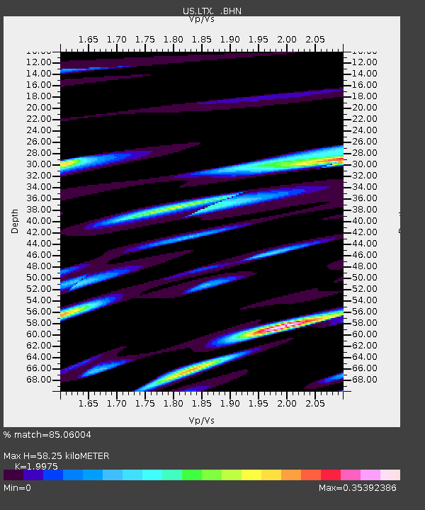
| Estimated Moho Depth: |
58.25 km |
| Estimated Crust Vp/Vs: |
2.00 |
| Assumed Crust Vp: |
6.419 km/s |
| Estimated Crust Vs: |
3.214 km/s |
| Estimated Crust Poisson's Ratio: |
0.33 |
|
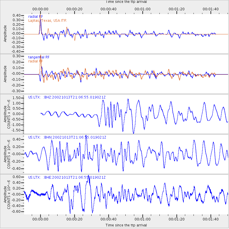
| Radial Match: |
85.06004 % |
| Radial Bump: |
400 |
| Transverse Match: |
67.021225 % |
| Transverse Bump: |
400 |
| SOD ConfigId: |
110177 |
| Insert Time: |
2010-03-05 07:03:30.398 +0000 |
| GWidth: |
2.5 |
| Max Bumps: |
400 |
| Tol: |
0.001 |
|
Signal To Noise
| Channel | StoN | STA | LTA |
| US:LTX: :BHN:20021013T21:06:55.019021Z | 1.7491505 | 1.9897625E-7 | 1.1375594E-7 |
| US:LTX: :BHE:20021013T21:06:55.019021Z | 0.75291437 | 6.7246006E-8 | 8.9314284E-8 |
| US:LTX: :BHZ:20021013T21:06:55.019021Z | 3.3515167 | 4.5201833E-7 | 1.3486978E-7 |
| Arrivals |
| Ps | 9.3 SECOND |
| PpPs | 27 SECOND |
| PsPs/PpSs | 36 SECOND |


