You are here: Home > Network List > US - United States National Seismic Network Stations List
> Station LTX Lajitas, Texas, USA > Earthquake Result Viewer
LTX Lajitas, Texas, USA - Earthquake Result Viewer
| Earthquake location: |
Southeast Of Loyalty Islands |
| Earthquake latitude/longitude: |
-21.7/169.8 |
| Earthquake time(UTC): |
2003/12/27 (361) 22:38:01 GMT |
| Earthquake Depth: |
10 km |
| Earthquake Magnitude: |
5.8 MB, 6.7 MS, 6.7 MW, 6.7 MW |
| Earthquake Catalog/Contributor: |
WHDF/NEIC |
|
| Network: |
US United States National Seismic Network |
| Station: |
LTX Lajitas, Texas, USA |
| Lat/Lon: |
29.33 N/103.67 W |
| Elevation: |
1013 m |
|
| Distance: |
97.4 deg |
| Az: |
61.514 deg |
| Baz: |
249.437 deg |
| Ray Param: |
0.0402162 |
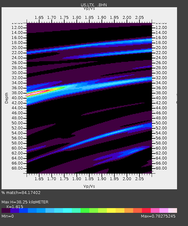
| Estimated Moho Depth: |
38.25 km |
| Estimated Crust Vp/Vs: |
1.62 |
| Assumed Crust Vp: |
6.419 km/s |
| Estimated Crust Vs: |
3.975 km/s |
| Estimated Crust Poisson's Ratio: |
0.19 |
|
| Radial Match: |
84.17402 % |
| Radial Bump: |
327 |
| Transverse Match: |
60.37762 % |
| Transverse Bump: |
378 |
| SOD ConfigId: |
110165 |
| Insert Time: |
2010-03-05 07:03:33.120 +0000 |
| GWidth: |
2.5 |
| Max Bumps: |
400 |
| Tol: |
0.001 |
|
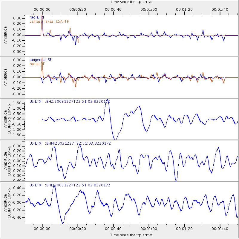
Signal To Noise
| Channel | StoN | STA | LTA |
| US:LTX: :BHN:20031227T22:51:03.822017Z | 0.43028522 | 4.543807E-8 | 1.0559989E-7 |
| US:LTX: :BHE:20031227T22:51:03.822017Z | 0.3813483 | 5.8138173E-8 | 1.5245426E-7 |
| US:LTX: :BHZ:20031227T22:51:03.822017Z | 1.6605992 | 1.7415836E-7 | 1.0487681E-7 |
| Arrivals |
| Ps | 3.7 SECOND |
| PpPs | 15 SECOND |
| PsPs/PpSs | 19 SECOND |


