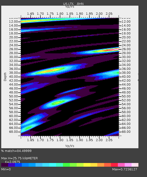
LTX Lajitas, Texas, USA - Earthquake Result Viewer
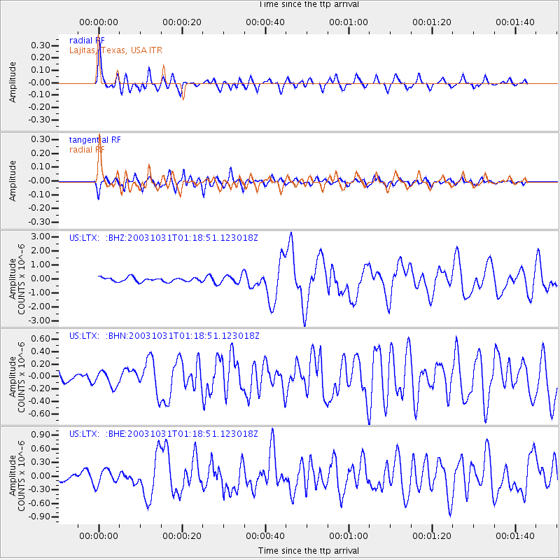
Earthquake location: Off East Coast Of Honshu, Japan
Earthquake latitude/longitude: 37.8/142.6
Earthquake time(UTC): 2003/10/31 (304) 01:06:28 GMT
Earthquake Depth: 10 km
Earthquake Magnitude: 6.1 MB, 6.8 MS, 7.0 MW, 7.0 MW
Earthquake Catalog/Contributor: WHDF/NEIC
Network: US United States National Seismic Network
Station: LTX Lajitas, Texas, USA
Lat/Lon: 29.33 N/103.67 W
Elevation: 1013 m
Distance: 88.9 deg
Az: 53.092 deg
Baz: 313.508 deg
Ray Param: 0.042251904
Estimated Moho Depth: 25.75 km
Estimated Crust Vp/Vs: 2.10
Assumed Crust Vp: 6.419 km/s
Estimated Crust Vs: 3.06 km/s
Estimated Crust Poisson's Ratio: 0.35
Radial Match: 84.49999 %
Radial Bump: 400
Transverse Match: 75.78074 %
Transverse Bump: 400
SOD ConfigId: 110165
Insert Time: 2010-03-05 07:03:37.854 +0000
GWidth: 2.5
Max Bumps: 400
Tol: 0.001

Signal To Noise

ChannelStoNSTALTA
US:LTX: :BHN:20031031T01:18:51.123018Z1.20198351.2190313E-71.014183E-7
US:LTX: :BHE:20031031T01:18:51.123018Z2.0258141.6175514E-77.984698E-8
US:LTX: :BHZ:20031031T01:18:51.123018Z2.0267352.961605E-71.4612688E-7
Arrivals
Ps4.5 SECOND
PpPs12 SECOND
PsPs/PpSs17 SECOND