You are here: Home > Network List > TA - USArray Transportable Network (new EarthScope stations) Stations List
> Station F21K Alatna River, AK, USA > Earthquake Result Viewer
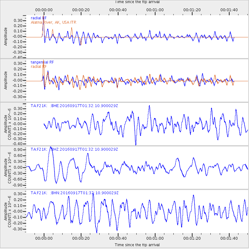
F21K Alatna River, AK, USA - Earthquake Result Viewer
*The percent match for this event was below the threshold and hence no stack was calculated.
| Earthquake location: |
Near North Coast Of Irian Jaya |
| Earthquake latitude/longitude: |
-2.1/140.6 |
| Earthquake time(UTC): |
2016/09/17 (261) 01:20:18 GMT |
| Earthquake Depth: |
10 km |
| Earthquake Magnitude: |
5.9 MWP |
| Earthquake Catalog/Contributor: |
NEIC PDE/NEIC COMCAT |
|
| Network: |
TA USArray Transportable Network (new EarthScope stations) |
| Station: |
F21K Alatna River, AK, USA |
| Lat/Lon: |
67.22 N/153.48 W |
| Elevation: |
597 m |
|
| Distance: |
82.8 deg |
| Az: |
21.0 deg |
| Baz: |
246.887 deg |
| Ray Param: |
$rayparam |
*The percent match for this event was below the threshold and hence was not used in the summary stack. |
|
| Radial Match: |
72.83486 % |
| Radial Bump: |
400 |
| Transverse Match: |
70.01356 % |
| Transverse Bump: |
400 |
| SOD ConfigId: |
11737051 |
| Insert Time: |
2019-04-25 13:20:07.974 +0000 |
| GWidth: |
2.5 |
| Max Bumps: |
400 |
| Tol: |
0.001 |
|
Signal To Noise
| Channel | StoN | STA | LTA |
| TA:F21K: :BHZ:20160917T01:32:10.900029Z | 8.032848 | 6.737382E-7 | 8.3872884E-8 |
| TA:F21K: :BHN:20160917T01:32:10.900029Z | 1.6603183 | 1.08676105E-7 | 6.5454984E-8 |
| TA:F21K: :BHE:20160917T01:32:10.900029Z | 2.1762125 | 1.4956392E-7 | 6.8726706E-8 |
| Arrivals |
| Ps | |
| PpPs | |
| PsPs/PpSs | |


