You are here: Home > Network List > TA - USArray Transportable Network (new EarthScope stations) Stations List
> Station G24K Hadweenzic River, AK, USA > Earthquake Result Viewer
G24K Hadweenzic River, AK, USA - Earthquake Result Viewer
| Earthquake location: |
Near North Coast Of Irian Jaya |
| Earthquake latitude/longitude: |
-2.1/140.6 |
| Earthquake time(UTC): |
2016/09/17 (261) 01:20:18 GMT |
| Earthquake Depth: |
10 km |
| Earthquake Magnitude: |
5.9 MWP |
| Earthquake Catalog/Contributor: |
NEIC PDE/NEIC COMCAT |
|
| Network: |
TA USArray Transportable Network (new EarthScope stations) |
| Station: |
G24K Hadweenzic River, AK, USA |
| Lat/Lon: |
66.70 N/147.48 W |
| Elevation: |
503 m |
|
| Distance: |
84.9 deg |
| Az: |
22.317 deg |
| Baz: |
252.552 deg |
| Ray Param: |
0.045176473 |
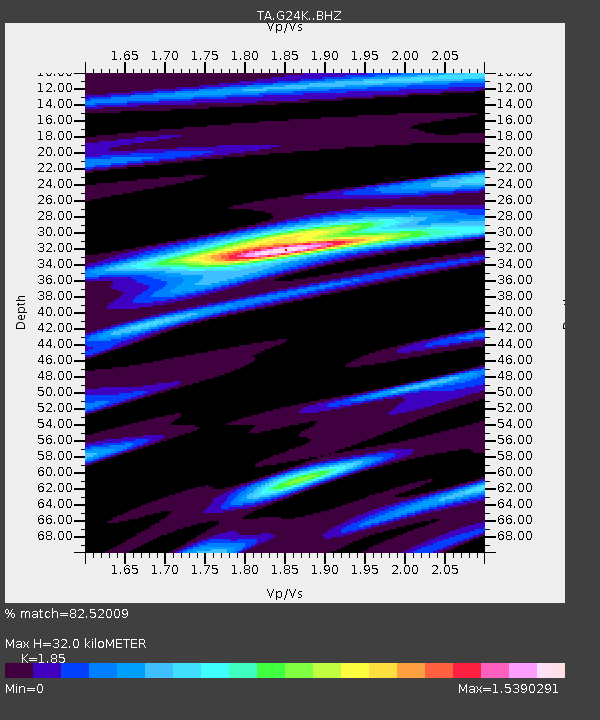
| Estimated Moho Depth: |
32.0 km |
| Estimated Crust Vp/Vs: |
1.85 |
| Assumed Crust Vp: |
6.522 km/s |
| Estimated Crust Vs: |
3.525 km/s |
| Estimated Crust Poisson's Ratio: |
0.29 |
|
| Radial Match: |
82.52009 % |
| Radial Bump: |
400 |
| Transverse Match: |
64.28856 % |
| Transverse Bump: |
400 |
| SOD ConfigId: |
11737051 |
| Insert Time: |
2019-04-25 13:20:14.632 +0000 |
| GWidth: |
2.5 |
| Max Bumps: |
400 |
| Tol: |
0.001 |
|

Signal To Noise
| Channel | StoN | STA | LTA |
| TA:G24K: :BHZ:20160917T01:32:21.275029Z | 8.939802 | 8.127158E-7 | 9.090982E-8 |
| TA:G24K: :BHN:20160917T01:32:21.275029Z | 0.8286728 | 1.09184406E-7 | 1.3175816E-7 |
| TA:G24K: :BHE:20160917T01:32:21.275029Z | 3.2862024 | 3.6942154E-7 | 1.1241595E-7 |
| Arrivals |
| Ps | 4.3 SECOND |
| PpPs | 14 SECOND |
| PsPs/PpSs | 18 SECOND |


