You are here: Home > Network List > US - United States National Seismic Network Stations List
> Station LTX Lajitas, Texas, USA > Earthquake Result Viewer
LTX Lajitas, Texas, USA - Earthquake Result Viewer
| Earthquake location: |
South Of Panama |
| Earthquake latitude/longitude: |
5.7/-82.7 |
| Earthquake time(UTC): |
2003/05/23 (143) 11:05:11 GMT |
| Earthquake Depth: |
10 km |
| Earthquake Magnitude: |
5.1 MB, 5.4 MS, 5.9 MW, 5.9 MW |
| Earthquake Catalog/Contributor: |
WHDF/NEIC |
|
| Network: |
US United States National Seismic Network |
| Station: |
LTX Lajitas, Texas, USA |
| Lat/Lon: |
29.33 N/103.67 W |
| Elevation: |
1013 m |
|
| Distance: |
30.8 deg |
| Az: |
322.285 deg |
| Baz: |
135.798 deg |
| Ray Param: |
0.07923911 |
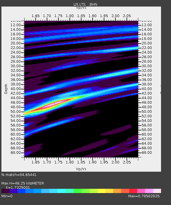
| Estimated Moho Depth: |
46.25 km |
| Estimated Crust Vp/Vs: |
1.73 |
| Assumed Crust Vp: |
6.419 km/s |
| Estimated Crust Vs: |
3.705 km/s |
| Estimated Crust Poisson's Ratio: |
0.25 |
|
| Radial Match: |
84.65441 % |
| Radial Bump: |
368 |
| Transverse Match: |
62.312386 % |
| Transverse Bump: |
400 |
| SOD ConfigId: |
110165 |
| Insert Time: |
2010-03-05 07:03:44.946 +0000 |
| GWidth: |
2.5 |
| Max Bumps: |
400 |
| Tol: |
0.001 |
|
Signal To Noise
| Channel | StoN | STA | LTA |
| US:LTX: :BHN:20030523T11:10:56.951006Z | 0.92933476 | 5.9342238E-8 | 6.3854536E-8 |
| US:LTX: :BHE:20030523T11:10:56.951006Z | 0.8582778 | 7.213826E-8 | 8.405002E-8 |
| US:LTX: :BHZ:20030523T11:10:56.951006Z | 3.0273666 | 2.0916711E-7 | 6.9092096E-8 |
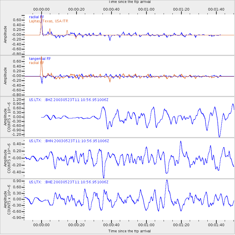
| Arrivals |
| Ps | 5.7 SECOND |
| PpPs | 18 SECOND |
| PsPs/PpSs | 24 SECOND |


