You are here: Home > Network List > US - United States National Seismic Network Stations List
> Station LTX Lajitas, Texas, USA > Earthquake Result Viewer
LTX Lajitas, Texas, USA - Earthquake Result Viewer
| Earthquake location: |
Northern Algeria |
| Earthquake latitude/longitude: |
37.0/3.6 |
| Earthquake time(UTC): |
2003/05/21 (141) 18:44:20 GMT |
| Earthquake Depth: |
12 km |
| Earthquake Magnitude: |
6.5 MB, 6.9 MS, 6.8 MW, 6.7 MW |
| Earthquake Catalog/Contributor: |
WHDF/NEIC |
|
| Network: |
US United States National Seismic Network |
| Station: |
LTX Lajitas, Texas, USA |
| Lat/Lon: |
29.33 N/103.67 W |
| Elevation: |
1013 m |
|
| Distance: |
85.2 deg |
| Az: |
303.215 deg |
| Baz: |
50.122 deg |
| Ray Param: |
0.0449384 |
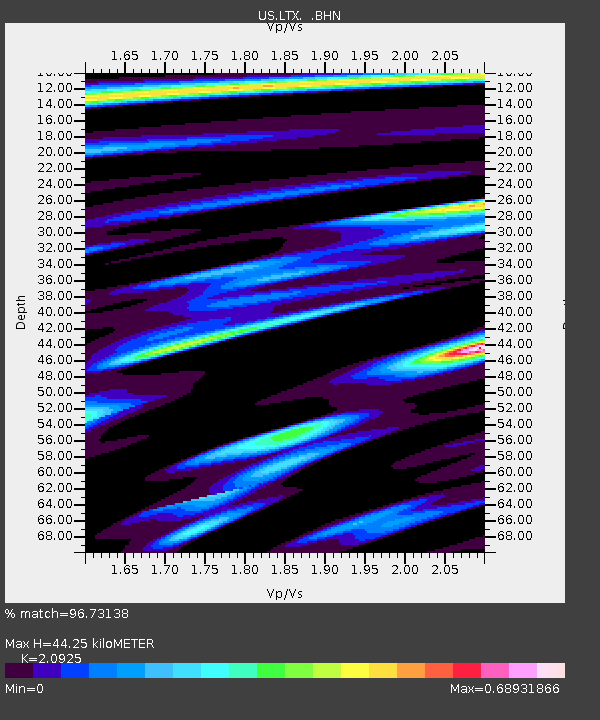
| Estimated Moho Depth: |
44.25 km |
| Estimated Crust Vp/Vs: |
2.09 |
| Assumed Crust Vp: |
6.419 km/s |
| Estimated Crust Vs: |
3.068 km/s |
| Estimated Crust Poisson's Ratio: |
0.35 |
|
| Radial Match: |
96.73138 % |
| Radial Bump: |
372 |
| Transverse Match: |
92.54442 % |
| Transverse Bump: |
400 |
| SOD ConfigId: |
110165 |
| Insert Time: |
2010-03-05 07:03:46.714 +0000 |
| GWidth: |
2.5 |
| Max Bumps: |
400 |
| Tol: |
0.001 |
|
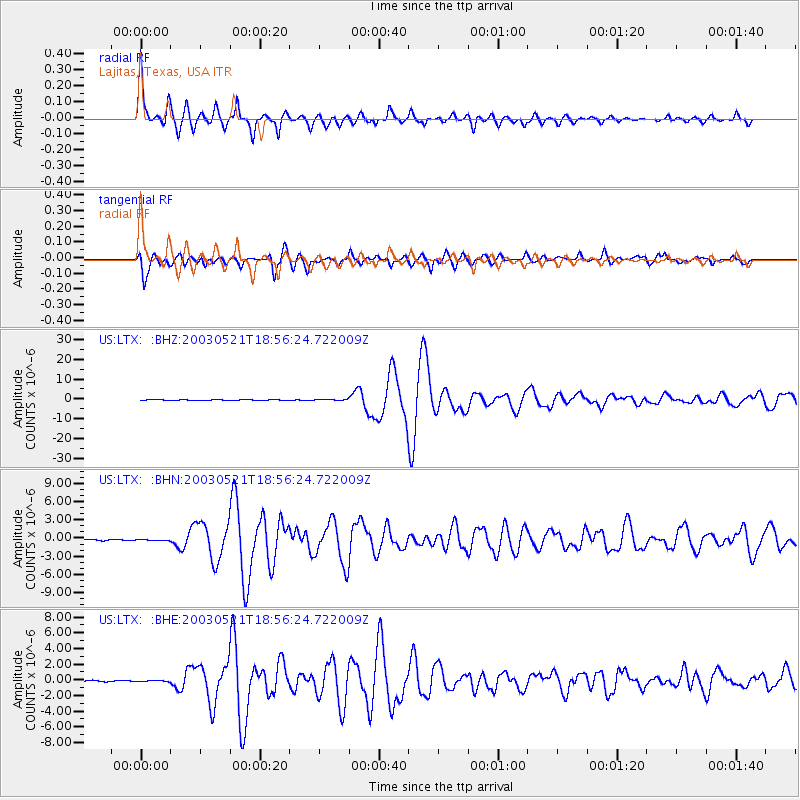
Signal To Noise
| Channel | StoN | STA | LTA |
| US:LTX: :BHN:20030521T18:56:24.722009Z | 0.7285983 | 4.452589E-8 | 6.111171E-8 |
| US:LTX: :BHE:20030521T18:56:24.722009Z | 0.7947654 | 8.4563915E-8 | 1.06401096E-7 |
| US:LTX: :BHZ:20030521T18:56:24.722009Z | 2.7549264 | 2.1940521E-7 | 7.964105E-8 |
| Arrivals |
| Ps | 7.7 SECOND |
| PpPs | 21 SECOND |
| PsPs/PpSs | 29 SECOND |


