You are here: Home > Network List > US - United States National Seismic Network Stations List
> Station LTX Lajitas, Texas, USA > Earthquake Result Viewer
LTX Lajitas, Texas, USA - Earthquake Result Viewer
| Earthquake location: |
Fiji Islands Region |
| Earthquake latitude/longitude: |
-20.6/-177.7 |
| Earthquake time(UTC): |
2003/01/04 (004) 05:15:03 GMT |
| Earthquake Depth: |
378 km |
| Earthquake Magnitude: |
6.0 MB, 6.5 MW, 6.5 MW |
| Earthquake Catalog/Contributor: |
WHDF/NEIC |
|
| Network: |
US United States National Seismic Network |
| Station: |
LTX Lajitas, Texas, USA |
| Lat/Lon: |
29.33 N/103.67 W |
| Elevation: |
1013 m |
|
| Distance: |
86.8 deg |
| Az: |
57.205 deg |
| Baz: |
244.432 deg |
| Ray Param: |
0.04279311 |
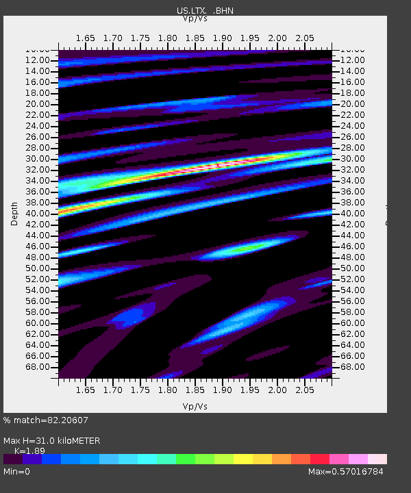
| Estimated Moho Depth: |
31.0 km |
| Estimated Crust Vp/Vs: |
1.89 |
| Assumed Crust Vp: |
6.419 km/s |
| Estimated Crust Vs: |
3.396 km/s |
| Estimated Crust Poisson's Ratio: |
0.31 |
|
| Radial Match: |
82.20607 % |
| Radial Bump: |
364 |
| Transverse Match: |
61.732086 % |
| Transverse Bump: |
387 |
| SOD ConfigId: |
110177 |
| Insert Time: |
2010-03-05 07:03:48.055 +0000 |
| GWidth: |
2.5 |
| Max Bumps: |
400 |
| Tol: |
0.001 |
|
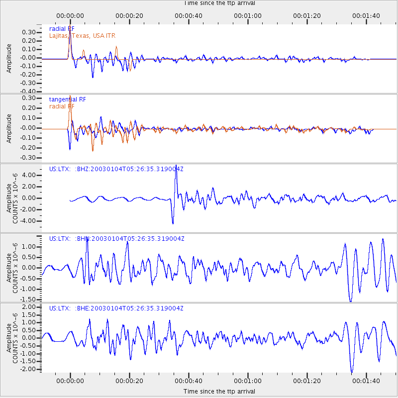
Signal To Noise
| Channel | StoN | STA | LTA |
| US:LTX: :BHN:20030104T05:26:35.319004Z | 1.9206294 | 3.343471E-7 | 1.7408205E-7 |
| US:LTX: :BHE:20030104T05:26:35.319004Z | 1.2334374 | 3.475828E-7 | 2.818001E-7 |
| US:LTX: :BHZ:20030104T05:26:35.319004Z | 4.4051957 | 1.2410627E-6 | 2.8172704E-7 |
| Arrivals |
| Ps | 4.4 SECOND |
| PpPs | 14 SECOND |
| PsPs/PpSs | 18 SECOND |


