You are here: Home > Network List > TA - USArray Transportable Network (new EarthScope stations) Stations List
> Station J25K Salcha River, AK, USA > Earthquake Result Viewer
J25K Salcha River, AK, USA - Earthquake Result Viewer
| Earthquake location: |
Near North Coast Of Irian Jaya |
| Earthquake latitude/longitude: |
-2.1/140.6 |
| Earthquake time(UTC): |
2016/09/17 (261) 01:20:18 GMT |
| Earthquake Depth: |
10 km |
| Earthquake Magnitude: |
5.9 MWP |
| Earthquake Catalog/Contributor: |
NEIC PDE/NEIC COMCAT |
|
| Network: |
TA USArray Transportable Network (new EarthScope stations) |
| Station: |
J25K Salcha River, AK, USA |
| Lat/Lon: |
64.61 N/145.37 W |
| Elevation: |
949 m |
|
| Distance: |
85.1 deg |
| Az: |
24.584 deg |
| Baz: |
254.667 deg |
| Ray Param: |
0.04499972 |
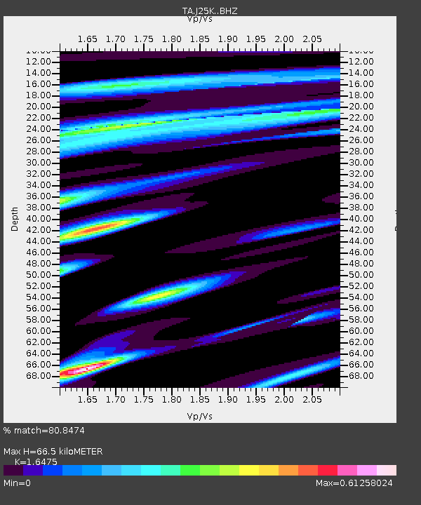
| Estimated Moho Depth: |
66.5 km |
| Estimated Crust Vp/Vs: |
1.65 |
| Assumed Crust Vp: |
6.566 km/s |
| Estimated Crust Vs: |
3.986 km/s |
| Estimated Crust Poisson's Ratio: |
0.21 |
|
| Radial Match: |
80.8474 % |
| Radial Bump: |
400 |
| Transverse Match: |
77.28969 % |
| Transverse Bump: |
400 |
| SOD ConfigId: |
11737051 |
| Insert Time: |
2019-04-25 13:20:28.303 +0000 |
| GWidth: |
2.5 |
| Max Bumps: |
400 |
| Tol: |
0.001 |
|
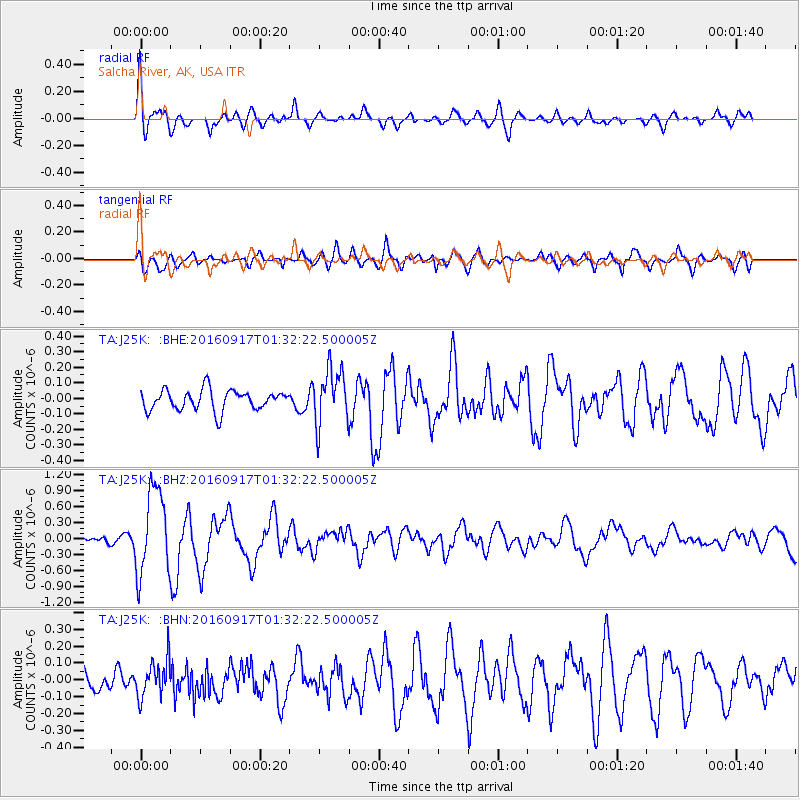
Signal To Noise
| Channel | StoN | STA | LTA |
| TA:J25K: :BHZ:20160917T01:32:22.500005Z | 8.296302 | 8.04293E-7 | 9.694596E-8 |
| TA:J25K: :BHN:20160917T01:32:22.500005Z | 1.3130196 | 1.1123958E-7 | 8.472042E-8 |
| TA:J25K: :BHE:20160917T01:32:22.500005Z | 2.774149 | 1.8089771E-7 | 6.520837E-8 |
| Arrivals |
| Ps | 6.7 SECOND |
| PpPs | 26 SECOND |
| PsPs/PpSs | 33 SECOND |


