You are here: Home > Network List > US - United States National Seismic Network Stations List
> Station LTX Lajitas, Texas, USA > Earthquake Result Viewer
LTX Lajitas, Texas, USA - Earthquake Result Viewer
| Earthquake location: |
Tonga Islands |
| Earthquake latitude/longitude: |
-15.3/-173.5 |
| Earthquake time(UTC): |
2003/03/28 (087) 17:31:47 GMT |
| Earthquake Depth: |
41 km |
| Earthquake Magnitude: |
5.8 MB, 6.0 MS, 6.2 MW, 6.1 MW |
| Earthquake Catalog/Contributor: |
WHDF/NEIC |
|
| Network: |
US United States National Seismic Network |
| Station: |
LTX Lajitas, Texas, USA |
| Lat/Lon: |
29.33 N/103.67 W |
| Elevation: |
1013 m |
|
| Distance: |
80.7 deg |
| Az: |
56.172 deg |
| Baz: |
246.63 deg |
| Ray Param: |
0.04806398 |
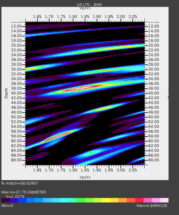
| Estimated Moho Depth: |
37.75 km |
| Estimated Crust Vp/Vs: |
1.83 |
| Assumed Crust Vp: |
6.419 km/s |
| Estimated Crust Vs: |
3.513 km/s |
| Estimated Crust Poisson's Ratio: |
0.29 |
|
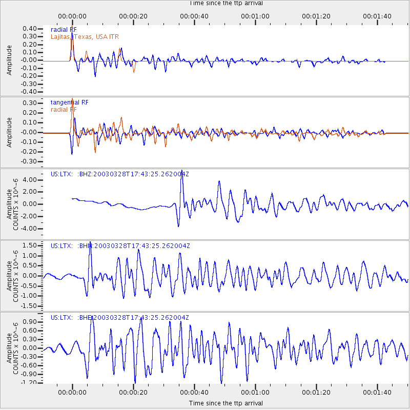
| Radial Match: |
88.82957 % |
| Radial Bump: |
304 |
| Transverse Match: |
86.18424 % |
| Transverse Bump: |
373 |
| SOD ConfigId: |
110177 |
| Insert Time: |
2010-03-05 07:03:51.219 +0000 |
| GWidth: |
2.5 |
| Max Bumps: |
400 |
| Tol: |
0.001 |
|
Signal To Noise
| Channel | StoN | STA | LTA |
| US:LTX: :BHN:20030328T17:43:25.262004Z | 2.7383196 | 3.062719E-7 | 1.1184665E-7 |
| US:LTX: :BHE:20030328T17:43:25.262004Z | 3.3331125 | 3.0151384E-7 | 9.046015E-8 |
| US:LTX: :BHZ:20030328T17:43:25.262004Z | 1.881314 | 1.0484353E-6 | 5.5728884E-7 |
| Arrivals |
| Ps | 5.0 SECOND |
| PpPs | 16 SECOND |
| PsPs/PpSs | 21 SECOND |


