You are here: Home > Network List > US - United States National Seismic Network Stations List
> Station LTX Lajitas, Texas, USA > Earthquake Result Viewer
LTX Lajitas, Texas, USA - Earthquake Result Viewer
| Earthquake location: |
North Atlantic Ocean |
| Earthquake latitude/longitude: |
18.3/-58.6 |
| Earthquake time(UTC): |
2003/05/14 (134) 06:03:35 GMT |
| Earthquake Depth: |
42 km |
| Earthquake Magnitude: |
6.5 MB, 6.5 MS, 6.6 MW, 6.6 MW |
| Earthquake Catalog/Contributor: |
WHDF/NEIC |
|
| Network: |
US United States National Seismic Network |
| Station: |
LTX Lajitas, Texas, USA |
| Lat/Lon: |
29.33 N/103.67 W |
| Elevation: |
1013 m |
|
| Distance: |
42.4 deg |
| Az: |
293.678 deg |
| Baz: |
94.7 deg |
| Ray Param: |
0.07309265 |
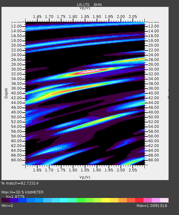
| Estimated Moho Depth: |
30.5 km |
| Estimated Crust Vp/Vs: |
1.88 |
| Assumed Crust Vp: |
6.419 km/s |
| Estimated Crust Vs: |
3.419 km/s |
| Estimated Crust Poisson's Ratio: |
0.30 |
|
| Radial Match: |
92.72314 % |
| Radial Bump: |
400 |
| Transverse Match: |
89.34741 % |
| Transverse Bump: |
400 |
| SOD ConfigId: |
110177 |
| Insert Time: |
2010-03-05 07:03:55.150 +0000 |
| GWidth: |
2.5 |
| Max Bumps: |
400 |
| Tol: |
0.001 |
|
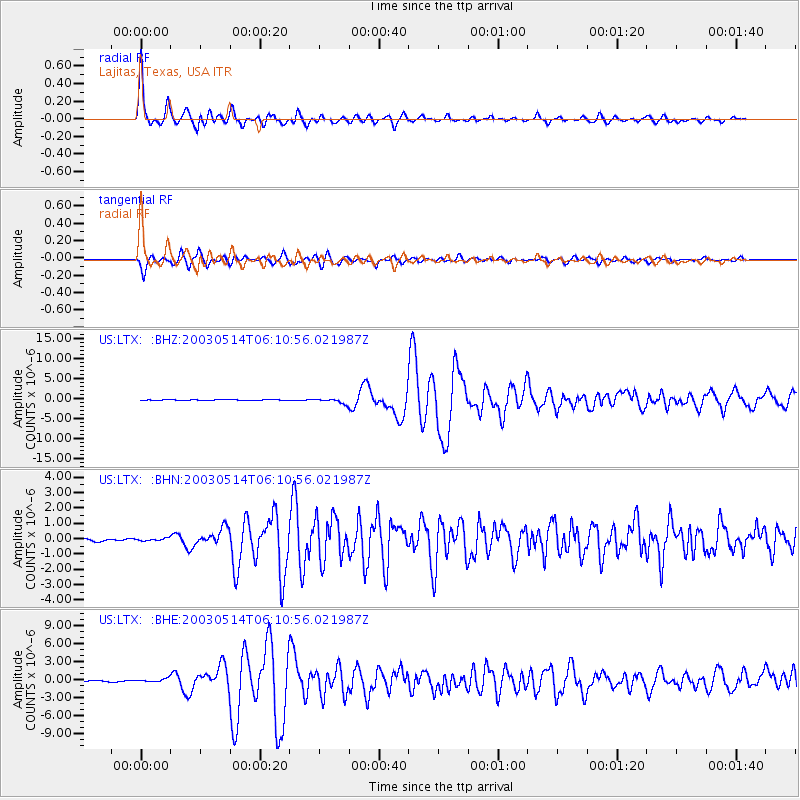
Signal To Noise
| Channel | StoN | STA | LTA |
| US:LTX: :BHN:20030514T06:10:56.021987Z | 1.3922012 | 8.85882E-8 | 6.363175E-8 |
| US:LTX: :BHE:20030514T06:10:56.021987Z | 4.8124247 | 2.9972932E-7 | 6.228239E-8 |
| US:LTX: :BHZ:20030514T06:10:56.021987Z | 7.8630104 | 6.732601E-7 | 8.562371E-8 |
| Arrivals |
| Ps | 4.4 SECOND |
| PpPs | 13 SECOND |
| PsPs/PpSs | 17 SECOND |


