You are here: Home > Network List > US - United States National Seismic Network Stations List
> Station LTX Lajitas, Texas, USA > Earthquake Result Viewer
LTX Lajitas, Texas, USA - Earthquake Result Viewer
| Earthquake location: |
Near East Coast Of Honshu, Japan |
| Earthquake latitude/longitude: |
38.8/141.6 |
| Earthquake time(UTC): |
2003/05/26 (146) 09:24:33 GMT |
| Earthquake Depth: |
68 km |
| Earthquake Magnitude: |
6.7 MB, 7.0 MW, 7.0 MW |
| Earthquake Catalog/Contributor: |
WHDF/NEIC |
|
| Network: |
US United States National Seismic Network |
| Station: |
LTX Lajitas, Texas, USA |
| Lat/Lon: |
29.33 N/103.67 W |
| Elevation: |
1013 m |
|
| Distance: |
88.9 deg |
| Az: |
52.468 deg |
| Baz: |
314.833 deg |
| Ray Param: |
0.04210453 |
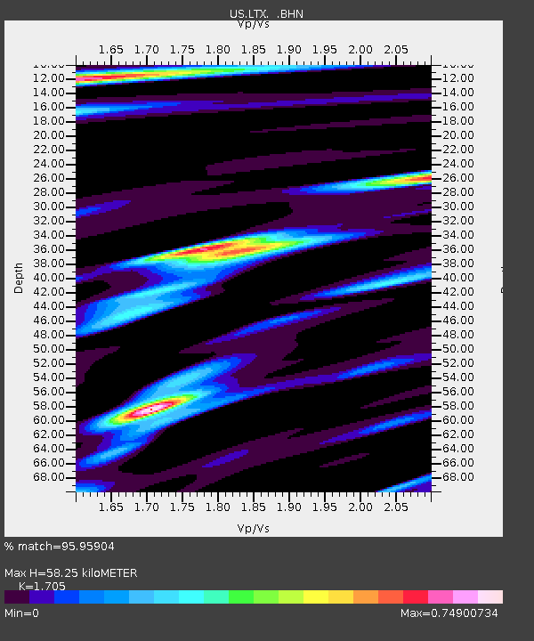
| Estimated Moho Depth: |
58.25 km |
| Estimated Crust Vp/Vs: |
1.71 |
| Assumed Crust Vp: |
6.419 km/s |
| Estimated Crust Vs: |
3.765 km/s |
| Estimated Crust Poisson's Ratio: |
0.24 |
|
| Radial Match: |
95.95904 % |
| Radial Bump: |
400 |
| Transverse Match: |
91.68573 % |
| Transverse Bump: |
400 |
| SOD ConfigId: |
110177 |
| Insert Time: |
2010-03-05 07:03:56.795 +0000 |
| GWidth: |
2.5 |
| Max Bumps: |
400 |
| Tol: |
0.001 |
|
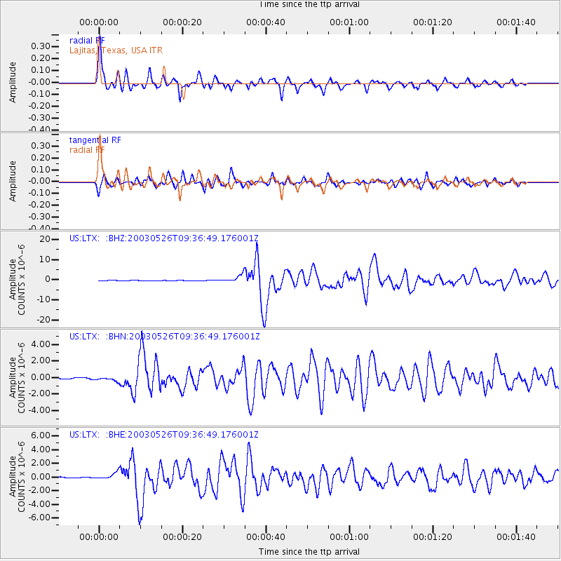
Signal To Noise
| Channel | StoN | STA | LTA |
| US:LTX: :BHN:20030526T09:36:49.176001Z | 3.4189548 | 2.1564105E-7 | 6.3072214E-8 |
| US:LTX: :BHE:20030526T09:36:49.176001Z | 5.975297 | 5.341764E-7 | 8.939747E-8 |
| US:LTX: :BHZ:20030526T09:36:49.176001Z | 25.036596 | 1.981107E-6 | 7.912845E-8 |
| Arrivals |
| Ps | 6.5 SECOND |
| PpPs | 24 SECOND |
| PsPs/PpSs | 31 SECOND |


