You are here: Home > Network List > US - United States National Seismic Network Stations List
> Station LTX Lajitas, Texas, USA > Earthquake Result Viewer
LTX Lajitas, Texas, USA - Earthquake Result Viewer
| Earthquake location: |
Near Coast Of Central Chile |
| Earthquake latitude/longitude: |
-30.6/-71.6 |
| Earthquake time(UTC): |
2003/06/20 (171) 13:30:41 GMT |
| Earthquake Depth: |
33 km |
| Earthquake Magnitude: |
6.4 MB, 6.8 MS, 6.8 MW, 6.7 MW |
| Earthquake Catalog/Contributor: |
WHDF/NEIC |
|
| Network: |
US United States National Seismic Network |
| Station: |
LTX Lajitas, Texas, USA |
| Lat/Lon: |
29.33 N/103.67 W |
| Elevation: |
1013 m |
|
| Distance: |
67.0 deg |
| Az: |
329.786 deg |
| Baz: |
150.206 deg |
| Ray Param: |
0.05721309 |
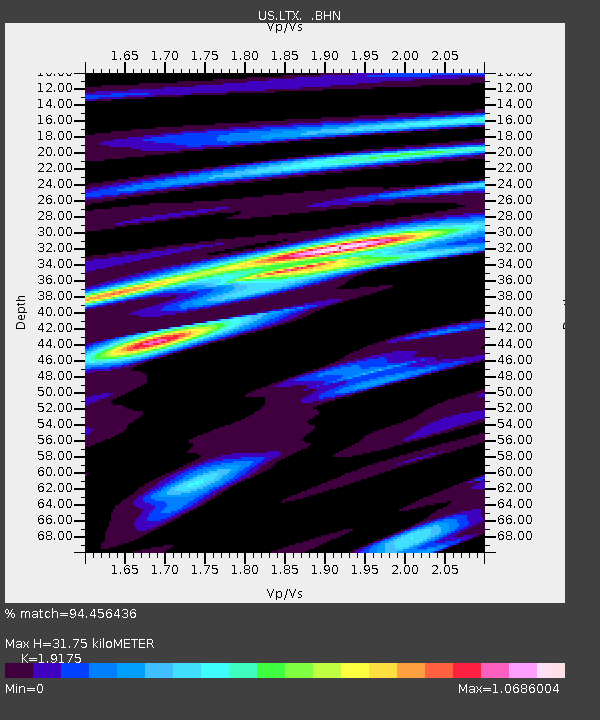
| Estimated Moho Depth: |
31.75 km |
| Estimated Crust Vp/Vs: |
1.92 |
| Assumed Crust Vp: |
6.419 km/s |
| Estimated Crust Vs: |
3.348 km/s |
| Estimated Crust Poisson's Ratio: |
0.31 |
|
| Radial Match: |
94.456436 % |
| Radial Bump: |
344 |
| Transverse Match: |
83.08128 % |
| Transverse Bump: |
400 |
| SOD ConfigId: |
110177 |
| Insert Time: |
2010-03-05 07:04:04.592 +0000 |
| GWidth: |
2.5 |
| Max Bumps: |
400 |
| Tol: |
0.001 |
|
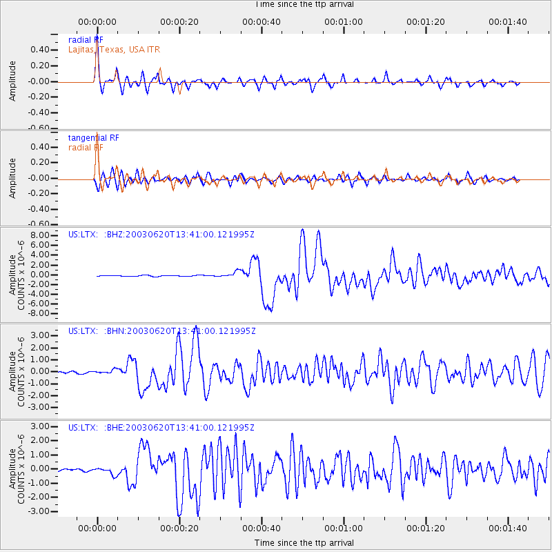
Signal To Noise
| Channel | StoN | STA | LTA |
| US:LTX: :BHN:20030620T13:41:00.121995Z | 3.101009 | 1.8161649E-7 | 5.8566904E-8 |
| US:LTX: :BHE:20030620T13:41:00.121995Z | 4.960338 | 2.671056E-7 | 5.3848265E-8 |
| US:LTX: :BHZ:20030620T13:41:00.121995Z | 6.595294 | 6.4956373E-7 | 9.8488975E-8 |
| Arrivals |
| Ps | 4.7 SECOND |
| PpPs | 14 SECOND |
| PsPs/PpSs | 19 SECOND |


