You are here: Home > Network List > TM - Thai Seismic Monitoring Network Stations List
> Station SKLT SKLT SongKhla Phase1 > Earthquake Result Viewer
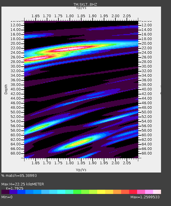
SKLT SKLT SongKhla Phase1 - Earthquake Result Viewer
| Earthquake location: |
Near North Coast Of Irian Jaya |
| Earthquake latitude/longitude: |
-2.1/140.6 |
| Earthquake time(UTC): |
2016/09/17 (261) 01:20:18 GMT |
| Earthquake Depth: |
10 km |
| Earthquake Magnitude: |
5.9 MWP |
| Earthquake Catalog/Contributor: |
NEIC PDE/NEIC COMCAT |
|
| Network: |
TM Thai Seismic Monitoring Network |
| Station: |
SKLT SKLT SongKhla Phase1 |
| Lat/Lon: |
7.18 N/100.62 E |
| Elevation: |
4.0 m |
|
| Distance: |
40.9 deg |
| Az: |
283.407 deg |
| Baz: |
101.575 deg |
| Ray Param: |
0.074110195 |
| Estimated Moho Depth: |
22.25 km |
| Estimated Crust Vp/Vs: |
1.79 |
| Assumed Crust Vp: |
6.468 km/s |
| Estimated Crust Vs: |
3.608 km/s |
| Estimated Crust Poisson's Ratio: |
0.27 |
|
| Radial Match: |
85.38993 % |
| Radial Bump: |
400 |
| Transverse Match: |
64.36807 % |
| Transverse Bump: |
400 |
| SOD ConfigId: |
11737051 |
| Insert Time: |
2019-04-25 13:21:16.659 +0000 |
| GWidth: |
2.5 |
| Max Bumps: |
400 |
| Tol: |
0.001 |
|

Signal To Noise
| Channel | StoN | STA | LTA |
| TM:SKLT: :BHZ:20160917T01:27:29.649999Z | 6.8568563 | 9.539535E-7 | 1.3912404E-7 |
| TM:SKLT: :BHN:20160917T01:27:29.649999Z | 0.5963383 | 8.935486E-8 | 1.4983922E-7 |
| TM:SKLT: :BHE:20160917T01:27:29.649999Z | 5.8151984 | 5.344092E-7 | 9.1898706E-8 |
| Arrivals |
| Ps | 2.9 SECOND |
| PpPs | 9.0 SECOND |
| PsPs/PpSs | 12 SECOND |


