You are here: Home > Network List > US - United States National Seismic Network Stations List
> Station LTX Lajitas, Texas, USA > Earthquake Result Viewer
LTX Lajitas, Texas, USA - Earthquake Result Viewer
| Earthquake location: |
Rat Islands, Aleutian Islands |
| Earthquake latitude/longitude: |
51.4/176.8 |
| Earthquake time(UTC): |
2003/06/23 (174) 12:12:34 GMT |
| Earthquake Depth: |
20 km |
| Earthquake Magnitude: |
6.3 MB, 7.0 MS, 6.9 MW, 6.8 MW |
| Earthquake Catalog/Contributor: |
WHDF/NEIC |
|
| Network: |
US United States National Seismic Network |
| Station: |
LTX Lajitas, Texas, USA |
| Lat/Lon: |
29.33 N/103.67 W |
| Elevation: |
1013 m |
|
| Distance: |
61.4 deg |
| Az: |
78.062 deg |
| Baz: |
315.468 deg |
| Ray Param: |
0.060898602 |
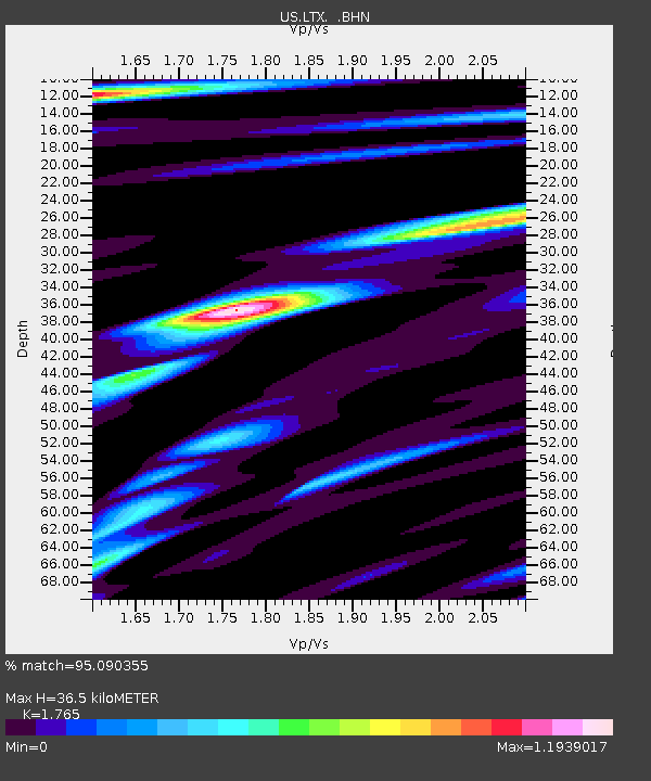
| Estimated Moho Depth: |
36.5 km |
| Estimated Crust Vp/Vs: |
1.76 |
| Assumed Crust Vp: |
6.419 km/s |
| Estimated Crust Vs: |
3.637 km/s |
| Estimated Crust Poisson's Ratio: |
0.26 |
|
| Radial Match: |
95.090355 % |
| Radial Bump: |
400 |
| Transverse Match: |
91.742966 % |
| Transverse Bump: |
400 |
| SOD ConfigId: |
110177 |
| Insert Time: |
2010-03-05 07:04:06.325 +0000 |
| GWidth: |
2.5 |
| Max Bumps: |
400 |
| Tol: |
0.001 |
|
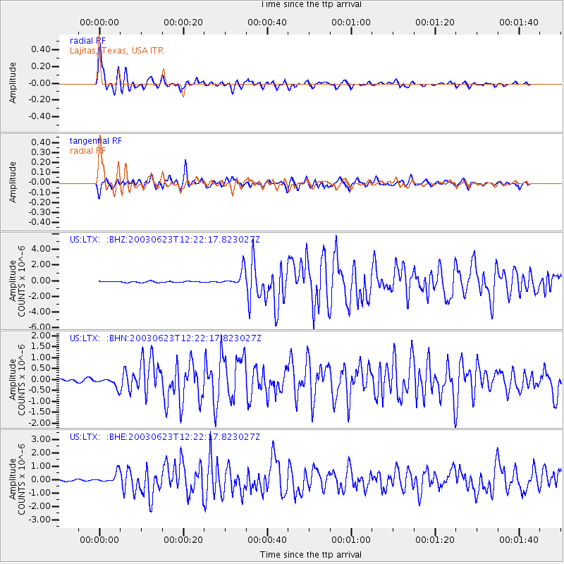
Signal To Noise
| Channel | StoN | STA | LTA |
| US:LTX: :BHN:20030623T12:22:17.823027Z | 5.822112 | 2.2530934E-7 | 3.86989E-8 |
| US:LTX: :BHE:20030623T12:22:17.823027Z | 8.066371 | 4.0404632E-7 | 5.0090218E-8 |
| US:LTX: :BHZ:20030623T12:22:17.823027Z | 15.2100935 | 1.0776591E-6 | 7.0851584E-8 |
| Arrivals |
| Ps | 4.6 SECOND |
| PpPs | 15 SECOND |
| PsPs/PpSs | 20 SECOND |


