You are here: Home > Network List > US - United States National Seismic Network Stations List
> Station LTX Lajitas, Texas, USA > Earthquake Result Viewer
LTX Lajitas, Texas, USA - Earthquake Result Viewer
| Earthquake location: |
Leeward Islands |
| Earthquake latitude/longitude: |
17.5/-61.1 |
| Earthquake time(UTC): |
2003/06/30 (181) 00:07:27 GMT |
| Earthquake Depth: |
33 km |
| Earthquake Magnitude: |
5.2 MB, 5.4 MS, 5.7 MW, 5.7 MW |
| Earthquake Catalog/Contributor: |
WHDF/NEIC |
|
| Network: |
US United States National Seismic Network |
| Station: |
LTX Lajitas, Texas, USA |
| Lat/Lon: |
29.33 N/103.67 W |
| Elevation: |
1013 m |
|
| Distance: |
40.6 deg |
| Az: |
294.852 deg |
| Baz: |
97.288 deg |
| Ray Param: |
0.07425759 |
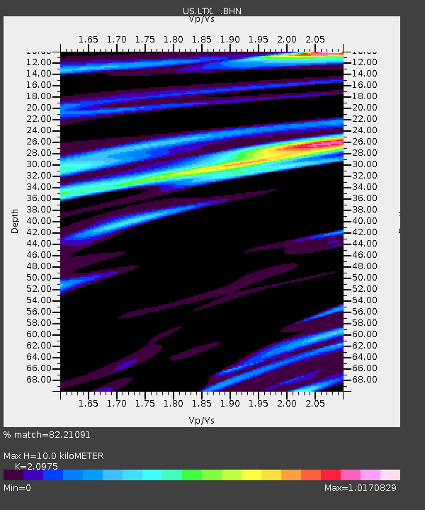
| Estimated Moho Depth: |
10.0 km |
| Estimated Crust Vp/Vs: |
2.10 |
| Assumed Crust Vp: |
6.419 km/s |
| Estimated Crust Vs: |
3.06 km/s |
| Estimated Crust Poisson's Ratio: |
0.35 |
|
| Radial Match: |
82.21091 % |
| Radial Bump: |
400 |
| Transverse Match: |
75.8303 % |
| Transverse Bump: |
400 |
| SOD ConfigId: |
110177 |
| Insert Time: |
2010-03-05 07:04:08.171 +0000 |
| GWidth: |
2.5 |
| Max Bumps: |
400 |
| Tol: |
0.001 |
|
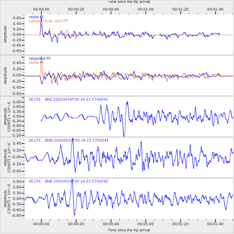
Signal To Noise
| Channel | StoN | STA | LTA |
| US:LTX: :BHN:20030630T00:14:33.570004Z | 0.83540374 | 8.418405E-8 | 1.0077051E-7 |
| US:LTX: :BHE:20030630T00:14:33.570004Z | 1.9409108 | 1.9004194E-7 | 9.791379E-8 |
| US:LTX: :BHZ:20030630T00:14:33.570004Z | 2.3882601 | 2.7629966E-7 | 1.1569078E-7 |
| Arrivals |
| Ps | 1.8 SECOND |
| PpPs | 4.6 SECOND |
| PsPs/PpSs | 6.4 SECOND |


