You are here: Home > Network List > US - United States National Seismic Network Stations List
> Station LTX Lajitas, Texas, USA > Earthquake Result Viewer
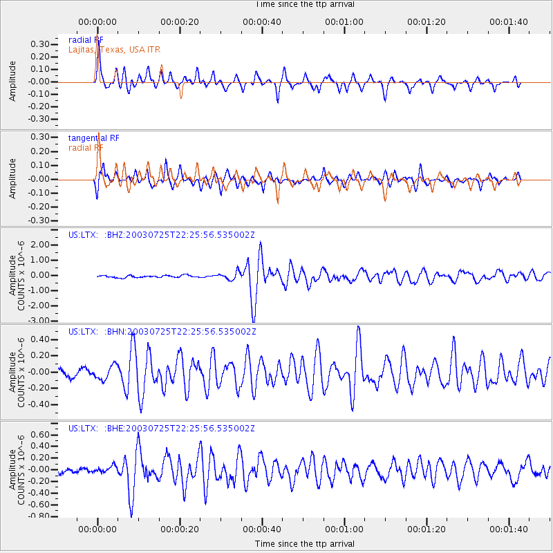
LTX Lajitas, Texas, USA - Earthquake Result Viewer

| Earthquake location: |
Eastern Honshu, Japan |
| Earthquake latitude/longitude: |
38.4/141.0 |
| Earthquake time(UTC): |
2003/07/25 (206) 22:13:29 GMT |
| Earthquake Depth: |
6.0 km |
| Earthquake Magnitude: |
6.0 MB, 5.8 MS, 6.1 MW, 5.9 MW |
| Earthquake Catalog/Contributor: |
WHDF/NEIC |
|
| Network: |
US United States National Seismic Network |
| Station: |
LTX Lajitas, Texas, USA |
| Lat/Lon: |
29.33 N/103.67 W |
| Elevation: |
1013 m |
|
| Distance: |
89.5 deg |
| Az: |
52.112 deg |
| Baz: |
314.764 deg |
| Ray Param: |
0.041783523 |
| Estimated Moho Depth: |
59.25 km |
| Estimated Crust Vp/Vs: |
1.71 |
| Assumed Crust Vp: |
6.419 km/s |
| Estimated Crust Vs: |
3.765 km/s |
| Estimated Crust Poisson's Ratio: |
0.24 |
|
| Radial Match: |
86.08118 % |
| Radial Bump: |
400 |
| Transverse Match: |
85.53695 % |
| Transverse Bump: |
400 |
| SOD ConfigId: |
110177 |
| Insert Time: |
2010-03-05 07:04:09.557 +0000 |
| GWidth: |
2.5 |
| Max Bumps: |
400 |
| Tol: |
0.001 |
|
Signal To Noise
| Channel | StoN | STA | LTA |
| US:LTX: :BHN:20030725T22:25:56.535002Z | 1.2873726 | 8.827869E-8 | 6.857276E-8 |
| US:LTX: :BHE:20030725T22:25:56.535002Z | 0.815002 | 5.8434992E-8 | 7.1699205E-8 |
| US:LTX: :BHZ:20030725T22:25:56.535002Z | 3.5725634 | 2.5510823E-7 | 7.140762E-8 |
| Arrivals |
| Ps | 6.6 SECOND |
| PpPs | 24 SECOND |
| PsPs/PpSs | 31 SECOND |


