You are here: Home > Network List > US - United States National Seismic Network Stations List
> Station LTX Lajitas, Texas, USA > Earthquake Result Viewer
LTX Lajitas, Texas, USA - Earthquake Result Viewer
| Earthquake location: |
Dominican Republic Region |
| Earthquake latitude/longitude: |
19.8/-70.7 |
| Earthquake time(UTC): |
2003/09/22 (265) 04:45:36 GMT |
| Earthquake Depth: |
10 km |
| Earthquake Magnitude: |
6.2 MB, 6.6 MS, 6.5 MW, 6.4 MW |
| Earthquake Catalog/Contributor: |
WHDF/NEIC |
|
| Network: |
US United States National Seismic Network |
| Station: |
LTX Lajitas, Texas, USA |
| Lat/Lon: |
29.33 N/103.67 W |
| Elevation: |
1013 m |
|
| Distance: |
31.4 deg |
| Az: |
294.097 deg |
| Baz: |
100.093 deg |
| Ray Param: |
0.079081565 |
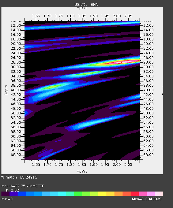
| Estimated Moho Depth: |
27.75 km |
| Estimated Crust Vp/Vs: |
2.02 |
| Assumed Crust Vp: |
6.419 km/s |
| Estimated Crust Vs: |
3.178 km/s |
| Estimated Crust Poisson's Ratio: |
0.34 |
|
| Radial Match: |
85.24915 % |
| Radial Bump: |
400 |
| Transverse Match: |
82.3486 % |
| Transverse Bump: |
400 |
| SOD ConfigId: |
110177 |
| Insert Time: |
2010-03-05 07:04:14.714 +0000 |
| GWidth: |
2.5 |
| Max Bumps: |
400 |
| Tol: |
0.001 |
|
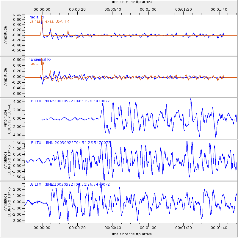
Signal To Noise
| Channel | StoN | STA | LTA |
| US:LTX: :BHN:20030922T04:51:26.547007Z | 1.0429232 | 1.5983132E-7 | 1.532532E-7 |
| US:LTX: :BHE:20030922T04:51:26.547007Z | 4.30766 | 8.3781555E-7 | 1.9449436E-7 |
| US:LTX: :BHZ:20030922T04:51:26.547007Z | 7.3293033 | 1.4178294E-6 | 1.9344668E-7 |
| Arrivals |
| Ps | 4.7 SECOND |
| PpPs | 12 SECOND |
| PsPs/PpSs | 17 SECOND |


