You are here: Home > Network List > US - United States National Seismic Network Stations List
> Station LTX Lajitas, Texas, USA > Earthquake Result Viewer
LTX Lajitas, Texas, USA - Earthquake Result Viewer
| Earthquake location: |
Hokkaido, Japan Region |
| Earthquake latitude/longitude: |
41.8/143.9 |
| Earthquake time(UTC): |
2003/09/25 (268) 19:50:06 GMT |
| Earthquake Depth: |
27 km |
| Earthquake Magnitude: |
6.9 MB, 8.1 MS, 8.3 MW, 8.1 MW |
| Earthquake Catalog/Contributor: |
WHDF/NEIC |
|
| Network: |
US United States National Seismic Network |
| Station: |
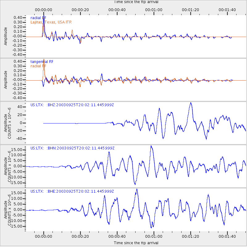
LTX Lajitas, Texas, USA |
| Lat/Lon: |
29.33 N/103.67 W |
| Elevation: |
1013 m |
|
| Distance: |
85.7 deg |
| Az: |
54.04 deg |
| Baz: |
316.136 deg |
| Ray Param: |
0.044536904 |
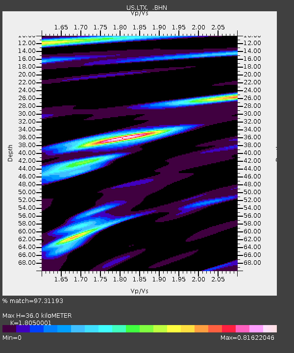
| Estimated Moho Depth: |
36.0 km |
| Estimated Crust Vp/Vs: |
1.81 |
| Assumed Crust Vp: |
6.419 km/s |
| Estimated Crust Vs: |
3.556 km/s |
| Estimated Crust Poisson's Ratio: |
0.28 |
|
| Radial Match: |
97.31193 % |
| Radial Bump: |
369 |
| Transverse Match: |
95.90068 % |
| Transverse Bump: |
400 |
| SOD ConfigId: |
110177 |
| Insert Time: |
2010-03-05 07:04:17.396 +0000 |
| GWidth: |
2.5 |
| Max Bumps: |
400 |
| Tol: |
0.001 |
|
Signal To Noise
| Channel | StoN | STA | LTA |
| US:LTX: :BHN:20030925T20:02:11.445999Z | 0.96841174 | 1.0273345E-7 | 1.0608448E-7 |
| US:LTX: :BHE:20030925T20:02:11.445999Z | 3.086169 | 1.9684765E-7 | 6.378382E-8 |
| US:LTX: :BHZ:20030925T20:02:11.445999Z | 2.4078052 | 4.1837671E-7 | 1.7375855E-7 |
| Arrivals |
| Ps | 4.6 SECOND |
| PpPs | 15 SECOND |
| PsPs/PpSs | 20 SECOND |


