You are here: Home > Network List > US - United States National Seismic Network Stations List
> Station LTX Lajitas, Texas, USA > Earthquake Result Viewer
LTX Lajitas, Texas, USA - Earthquake Result Viewer
| Earthquake location: |
Near West Coast Of Colombia |
| Earthquake latitude/longitude: |
5.0/-77.8 |
| Earthquake time(UTC): |
2003/11/05 (309) 00:58:51 GMT |
| Earthquake Depth: |
33 km |
| Earthquake Magnitude: |
5.7 MB, 5.4 MS, 6.0 MW, 5.9 MW |
| Earthquake Catalog/Contributor: |
WHDF/NEIC |
|
| Network: |
US United States National Seismic Network |
| Station: |
LTX Lajitas, Texas, USA |
| Lat/Lon: |
29.33 N/103.67 W |
| Elevation: |
1013 m |
|
| Distance: |
34.5 deg |
| Az: |
317.621 deg |
| Baz: |
129.73 deg |
| Ray Param: |
0.07767241 |
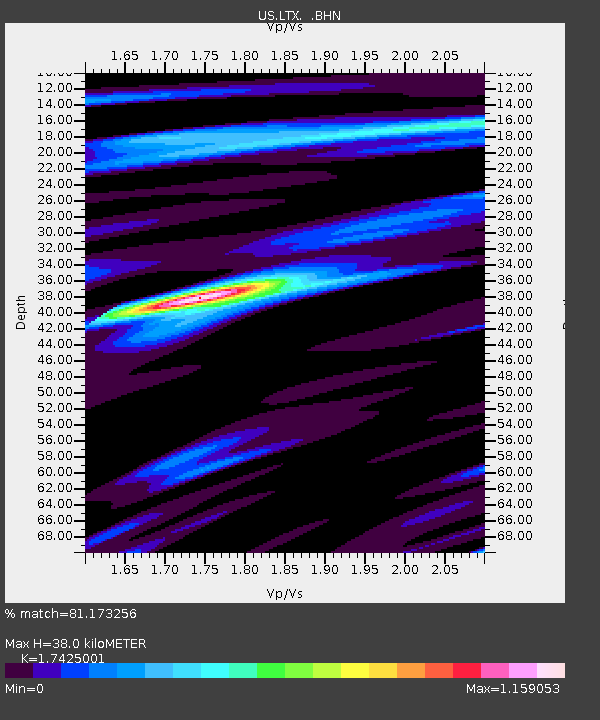
| Estimated Moho Depth: |
38.0 km |
| Estimated Crust Vp/Vs: |
1.74 |
| Assumed Crust Vp: |
6.419 km/s |
| Estimated Crust Vs: |
3.684 km/s |
| Estimated Crust Poisson's Ratio: |
0.25 |
|
| Radial Match: |
81.173256 % |
| Radial Bump: |
400 |
| Transverse Match: |
76.41833 % |
| Transverse Bump: |
400 |
| SOD ConfigId: |
110177 |
| Insert Time: |
2010-03-05 07:04:20.205 +0000 |
| GWidth: |
2.5 |
| Max Bumps: |
400 |
| Tol: |
0.001 |
|
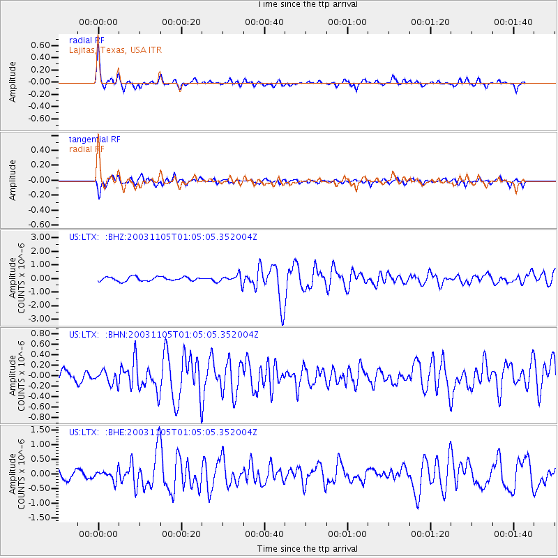
Signal To Noise
| Channel | StoN | STA | LTA |
| US:LTX: :BHN:20031105T01:05:05.352004Z | 1.1706691 | 1.2343662E-7 | 1.0544109E-7 |
| US:LTX: :BHE:20031105T01:05:05.352004Z | 1.2180078 | 1.771135E-7 | 1.4541246E-7 |
| US:LTX: :BHZ:20031105T01:05:05.352004Z | 2.1842728 | 3.215684E-7 | 1.4721988E-7 |
| Arrivals |
| Ps | 4.8 SECOND |
| PpPs | 15 SECOND |
| PsPs/PpSs | 20 SECOND |


