You are here: Home > Network List > US - United States National Seismic Network Stations List
> Station LTX Lajitas, Texas, USA > Earthquake Result Viewer
LTX Lajitas, Texas, USA - Earthquake Result Viewer
| Earthquake location: |
Rat Islands, Aleutian Islands |
| Earthquake latitude/longitude: |
51.1/178.6 |
| Earthquake time(UTC): |
2003/11/17 (321) 06:43:06 GMT |
| Earthquake Depth: |
33 km |
| Earthquake Magnitude: |
6.2 MB, 7.2 MS, 7.8 MW, 7.7 MW |
| Earthquake Catalog/Contributor: |
WHDF/NEIC |
|
| Network: |
US United States National Seismic Network |
| Station: |
LTX Lajitas, Texas, USA |
| Lat/Lon: |
29.33 N/103.67 W |
| Elevation: |
1013 m |
|
| Distance: |
60.3 deg |
| Az: |
79.226 deg |
| Baz: |
314.874 deg |
| Ray Param: |
0.061585248 |
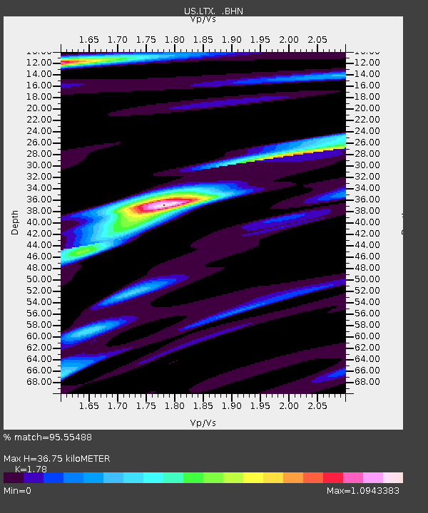
| Estimated Moho Depth: |
36.75 km |
| Estimated Crust Vp/Vs: |
1.78 |
| Assumed Crust Vp: |
6.419 km/s |
| Estimated Crust Vs: |
3.606 km/s |
| Estimated Crust Poisson's Ratio: |
0.27 |
|
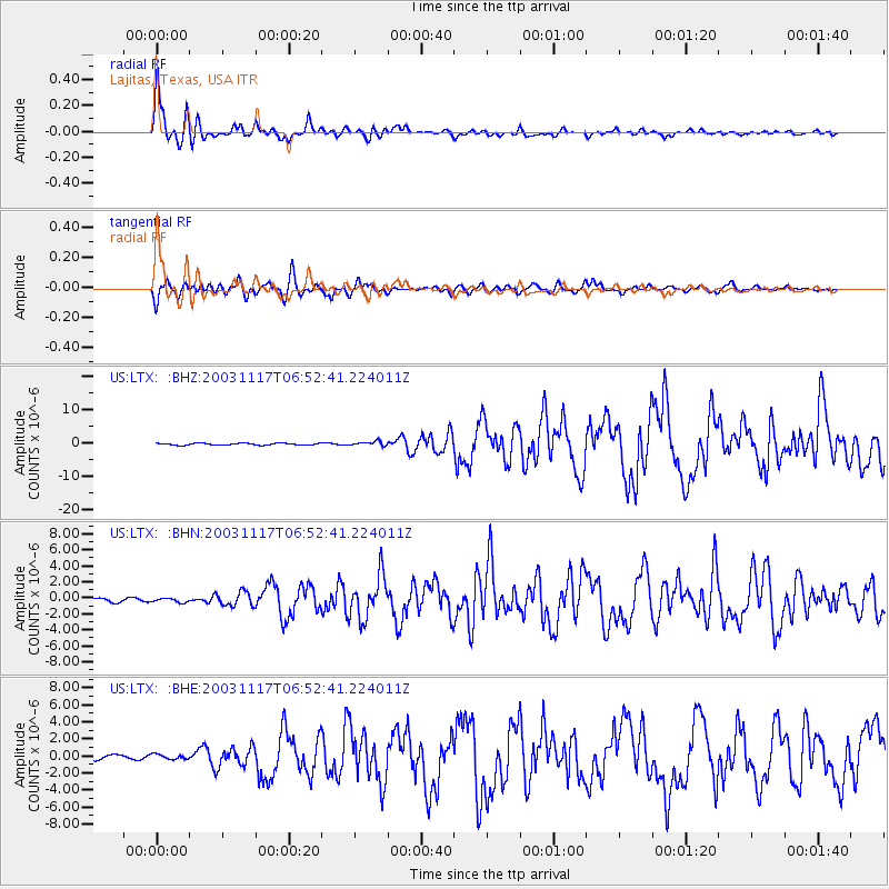
| Radial Match: |
95.55488 % |
| Radial Bump: |
368 |
| Transverse Match: |
88.309525 % |
| Transverse Bump: |
400 |
| SOD ConfigId: |
110177 |
| Insert Time: |
2010-03-05 07:04:22.365 +0000 |
| GWidth: |
2.5 |
| Max Bumps: |
400 |
| Tol: |
0.001 |
|
Signal To Noise
| Channel | StoN | STA | LTA |
| US:LTX: :BHN:20031117T06:52:41.224011Z | 1.4429996 | 2.6163596E-7 | 1.8131395E-7 |
| US:LTX: :BHE:20031117T06:52:41.224011Z | 0.8933666 | 2.7883564E-7 | 3.121178E-7 |
| US:LTX: :BHZ:20031117T06:52:41.224011Z | 2.269789 | 6.260613E-7 | 2.7582357E-7 |
| Arrivals |
| Ps | 4.7 SECOND |
| PpPs | 15 SECOND |
| PsPs/PpSs | 20 SECOND |


