You are here: Home > Network List > TJ - Tajikistan National Seismic Network Stations List
> Station GARM Garm, Tajikistan > Earthquake Result Viewer
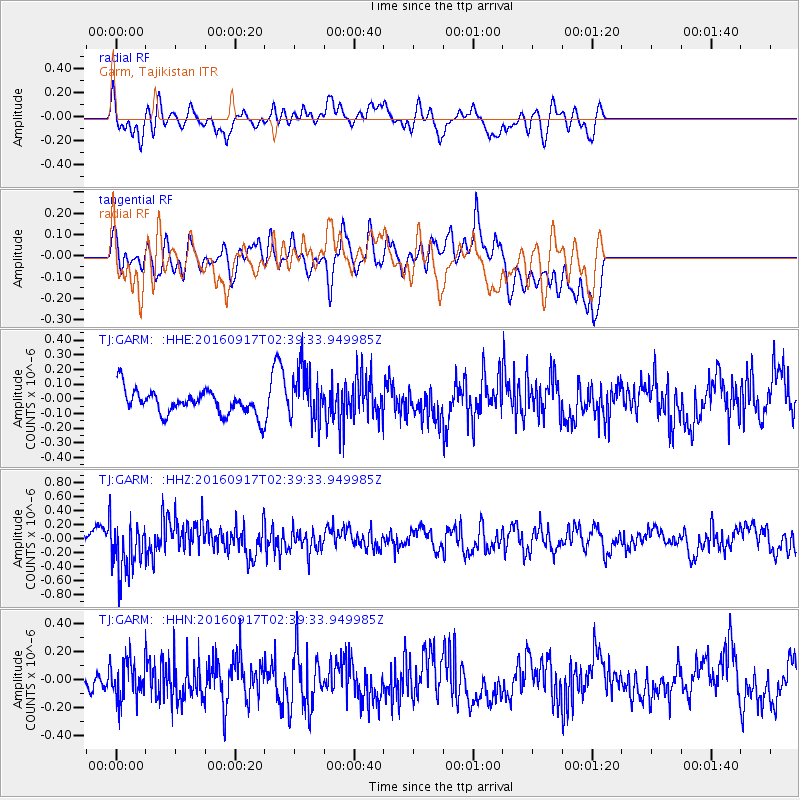
GARM Garm, Tajikistan - Earthquake Result Viewer
*The percent match for this event was below the threshold and hence no stack was calculated.
| Earthquake location: |
Southern Sumatra, Indonesia |
| Earthquake latitude/longitude: |
-4.4/102.8 |
| Earthquake time(UTC): |
2016/09/17 (261) 02:30:57 GMT |
| Earthquake Depth: |
60 km |
| Earthquake Magnitude: |
5.5 MB |
| Earthquake Catalog/Contributor: |
NEIC PDE/NEIC COMCAT |
|
| Network: |
TJ Tajikistan National Seismic Network |
| Station: |
GARM Garm, Tajikistan |
| Lat/Lon: |
39.00 N/70.32 E |
| Elevation: |
1305 m |
|
| Distance: |
52.6 deg |
| Az: |
328.188 deg |
| Baz: |
137.584 deg |
| Ray Param: |
$rayparam |
*The percent match for this event was below the threshold and hence was not used in the summary stack. |
|
| Radial Match: |
59.41834 % |
| Radial Bump: |
400 |
| Transverse Match: |
61.728374 % |
| Transverse Bump: |
400 |
| SOD ConfigId: |
11737051 |
| Insert Time: |
2019-04-25 13:25:05.784 +0000 |
| GWidth: |
2.5 |
| Max Bumps: |
400 |
| Tol: |
0.001 |
|
Signal To Noise
| Channel | StoN | STA | LTA |
| TJ:GARM: :HHZ:20160917T02:39:33.949985Z | 3.3882043 | 3.7537694E-7 | 1.1078935E-7 |
| TJ:GARM: :HHN:20160917T02:39:33.949985Z | 1.2324715 | 1.3795278E-7 | 1.1193183E-7 |
| TJ:GARM: :HHE:20160917T02:39:33.949985Z | 2.2194457 | 1.8103036E-7 | 8.1565574E-8 |
| Arrivals |
| Ps | |
| PpPs | |
| PsPs/PpSs | |


