You are here: Home > Network List > US - United States National Seismic Network Stations List
> Station WRAK Wrangell Island, Southeastern Alaska, Alaska, USA > Earthquake Result Viewer
WRAK Wrangell Island, Southeastern Alaska, Alaska, USA - Earthquake Result Viewer
| Earthquake location: |
Gulf Of California |
| Earthquake latitude/longitude: |
29.0/-112.9 |
| Earthquake time(UTC): |
2009/08/03 (215) 17:59:56 GMT |
| Earthquake Depth: |
10 km |
| Earthquake Magnitude: |
6.2 MB, 6.9 MW, 6.8 MW |
| Earthquake Catalog/Contributor: |
WHDF/NEIC |
|
| Network: |
US United States National Seismic Network |
| Station: |
WRAK Wrangell Island, Southeastern Alaska, Alaska, USA |
| Lat/Lon: |
56.42 N/132.35 W |
| Elevation: |
81 m |
|
| Distance: |
30.6 deg |
| Az: |
338.721 deg |
| Baz: |
145.12 deg |
| Ray Param: |
0.07927765 |
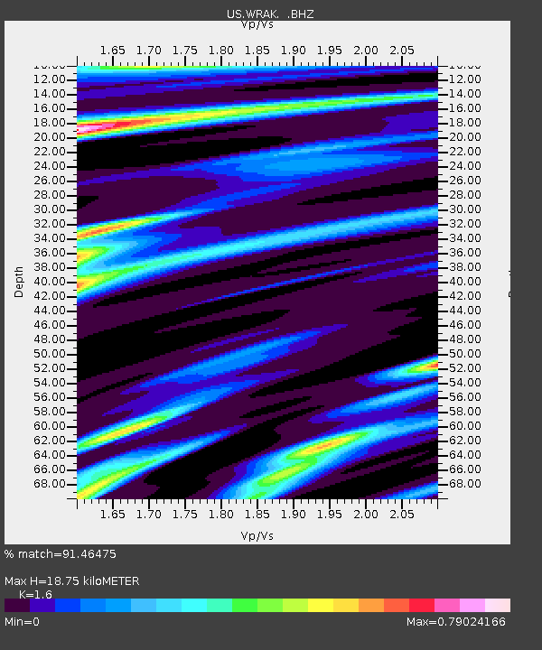
| Estimated Moho Depth: |
18.75 km |
| Estimated Crust Vp/Vs: |
1.60 |
| Assumed Crust Vp: |
6.597 km/s |
| Estimated Crust Vs: |
4.123 km/s |
| Estimated Crust Poisson's Ratio: |
0.18 |
|
| Radial Match: |
91.46475 % |
| Radial Bump: |
400 |
| Transverse Match: |
71.1657 % |
| Transverse Bump: |
400 |
| SOD ConfigId: |
2622 |
| Insert Time: |
2010-03-05 07:05:09.185 +0000 |
| GWidth: |
2.5 |
| Max Bumps: |
400 |
| Tol: |
0.001 |
|

Signal To Noise
| Channel | StoN | STA | LTA |
| US:WRAK: :BHZ:20090803T18:05:39.900011Z | 5.704545 | 7.5297464E-7 | 1.3199556E-7 |
| US:WRAK: :BHN:20090803T18:05:39.900011Z | 3.8051019 | 4.2572597E-7 | 1.1188294E-7 |
| US:WRAK: :BHE:20090803T18:05:39.900011Z | 2.1955419 | 2.8372727E-7 | 1.2922881E-7 |
| Arrivals |
| Ps | 1.9 SECOND |
| PpPs | 6.7 SECOND |
| PsPs/PpSs | 8.6 SECOND |


