You are here: Home > Network List > UW - Pacific Northwest Regional Seismic Network Stations List
> Station LEBA Lebam, WA, USA > Earthquake Result Viewer
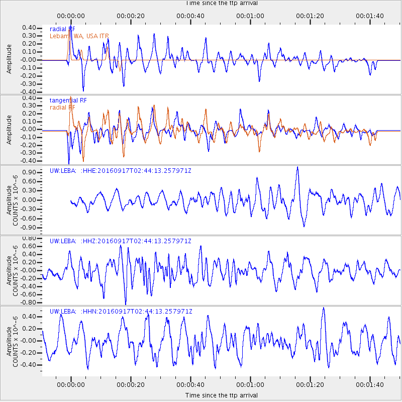
LEBA Lebam, WA, USA - Earthquake Result Viewer
*The percent match for this event was below the threshold and hence no stack was calculated.
| Earthquake location: |
Vanuatu Islands |
| Earthquake latitude/longitude: |
-16.0/167.4 |
| Earthquake time(UTC): |
2016/09/17 (261) 02:31:59 GMT |
| Earthquake Depth: |
37 km |
| Earthquake Magnitude: |
6.0 MWP |
| Earthquake Catalog/Contributor: |
NEIC PDE/NEIC COMCAT |
|
| Network: |
UW Pacific Northwest Regional Seismic Network |
| Station: |
LEBA Lebam, WA, USA |
| Lat/Lon: |
46.55 N/123.56 W |
| Elevation: |
73 m |
|
| Distance: |
87.7 deg |
| Az: |
40.157 deg |
| Baz: |
243.968 deg |
| Ray Param: |
$rayparam |
*The percent match for this event was below the threshold and hence was not used in the summary stack. |
|
| Radial Match: |
61.745754 % |
| Radial Bump: |
400 |
| Transverse Match: |
49.04398 % |
| Transverse Bump: |
400 |
| SOD ConfigId: |
11737051 |
| Insert Time: |
2019-04-25 13:32:06.280 +0000 |
| GWidth: |
2.5 |
| Max Bumps: |
400 |
| Tol: |
0.001 |
|
Signal To Noise
| Channel | StoN | STA | LTA |
| UW:LEBA: :HHZ:20160917T02:44:13.257971Z | 2.0775578 | 2.703006E-7 | 1.3010498E-7 |
| UW:LEBA: :HHN:20160917T02:44:13.257971Z | 1.0518826 | 1.8377331E-7 | 1.7470894E-7 |
| UW:LEBA: :HHE:20160917T02:44:13.257971Z | 1.0941261 | 1.9146813E-7 | 1.7499642E-7 |
| Arrivals |
| Ps | |
| PpPs | |
| PsPs/PpSs | |


