You are here: Home > Network List > UW - Pacific Northwest Regional Seismic Network Stations List
> Station MRBL Marblemount, WA, USA > Earthquake Result Viewer
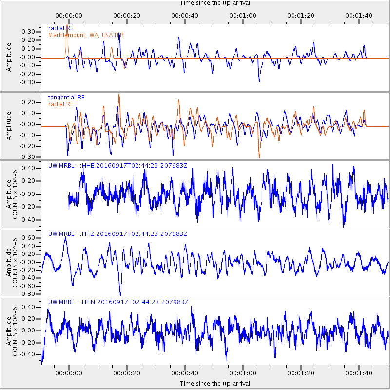
MRBL Marblemount, WA, USA - Earthquake Result Viewer
*The percent match for this event was below the threshold and hence no stack was calculated.
| Earthquake location: |
Vanuatu Islands |
| Earthquake latitude/longitude: |
-16.0/167.4 |
| Earthquake time(UTC): |
2016/09/17 (261) 02:31:59 GMT |
| Earthquake Depth: |
37 km |
| Earthquake Magnitude: |
6.0 MWP |
| Earthquake Catalog/Contributor: |
NEIC PDE/NEIC COMCAT |
|
| Network: |
UW Pacific Northwest Regional Seismic Network |
| Station: |
MRBL Marblemount, WA, USA |
| Lat/Lon: |
48.52 N/121.48 W |
| Elevation: |
75 m |
|
| Distance: |
89.9 deg |
| Az: |
38.974 deg |
| Baz: |
245.472 deg |
| Ray Param: |
$rayparam |
*The percent match for this event was below the threshold and hence was not used in the summary stack. |
|
| Radial Match: |
67.828766 % |
| Radial Bump: |
400 |
| Transverse Match: |
65.96963 % |
| Transverse Bump: |
400 |
| SOD ConfigId: |
11737051 |
| Insert Time: |
2019-04-25 13:32:06.308 +0000 |
| GWidth: |
2.5 |
| Max Bumps: |
400 |
| Tol: |
0.001 |
|
Signal To Noise
| Channel | StoN | STA | LTA |
| UW:MRBL: :HHZ:20160917T02:44:23.207983Z | 2.0243702 | 3.0557794E-7 | 1.5094963E-7 |
| UW:MRBL: :HHN:20160917T02:44:23.207983Z | 0.94097257 | 1.6284581E-7 | 1.7306117E-7 |
| UW:MRBL: :HHE:20160917T02:44:23.207983Z | 0.80806315 | 1.0504069E-7 | 1.299907E-7 |
| Arrivals |
| Ps | |
| PpPs | |
| PsPs/PpSs | |


