You are here: Home > Network List > US - United States National Seismic Network Stations List
> Station WRAK Wrangell Island, Southeastern Alaska, Alaska, USA > Earthquake Result Viewer
WRAK Wrangell Island, Southeastern Alaska, Alaska, USA - Earthquake Result Viewer
| Earthquake location: |
North Of Honduras |
| Earthquake latitude/longitude: |
16.7/-86.2 |
| Earthquake time(UTC): |
2009/05/28 (148) 08:24:45 GMT |
| Earthquake Depth: |
10 km |
| Earthquake Magnitude: |
6.7 MB, 7.2 MS, 7.3 MW, 7.3 MW |
| Earthquake Catalog/Contributor: |
WHDF/NEIC |
|
| Network: |
US United States National Seismic Network |
| Station: |
WRAK Wrangell Island, Southeastern Alaska, Alaska, USA |
| Lat/Lon: |
56.42 N/132.35 W |
| Elevation: |
81 m |
|
| Distance: |
52.6 deg |
| Az: |
329.742 deg |
| Baz: |
119.667 deg |
| Ray Param: |
0.06663189 |
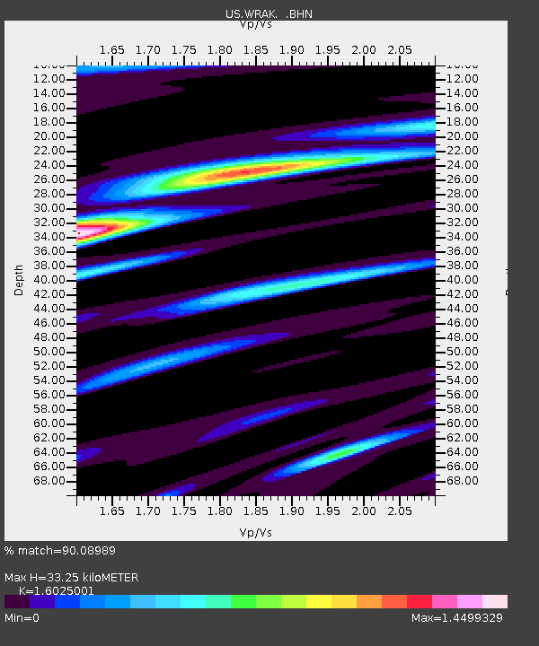
| Estimated Moho Depth: |
33.25 km |
| Estimated Crust Vp/Vs: |
1.60 |
| Assumed Crust Vp: |
6.597 km/s |
| Estimated Crust Vs: |
4.117 km/s |
| Estimated Crust Poisson's Ratio: |
0.18 |
|
| Radial Match: |
90.08989 % |
| Radial Bump: |
400 |
| Transverse Match: |
87.31154 % |
| Transverse Bump: |
400 |
| SOD ConfigId: |
2648 |
| Insert Time: |
2010-03-05 07:05:26.450 +0000 |
| GWidth: |
2.5 |
| Max Bumps: |
400 |
| Tol: |
0.001 |
|
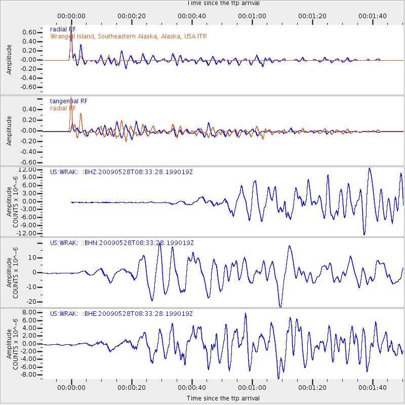
Signal To Noise
| Channel | StoN | STA | LTA |
| US:WRAK: :BHN:20090528T08:33:28.199019Z | 7.202784 | 7.643146E-7 | 1.0611378E-7 |
| US:WRAK: :BHE:20090528T08:33:28.199019Z | 2.9884408 | 2.0689468E-7 | 6.9231646E-8 |
| US:WRAK: :BHZ:20090528T08:33:28.199019Z | 4.5507174 | 3.0745417E-7 | 6.75617E-8 |
| Arrivals |
| Ps | 3.2 SECOND |
| PpPs | 12 SECOND |
| PsPs/PpSs | 16 SECOND |


