You are here: Home > Network List > CM - Red Sismologica Nacional de Columbia Stations List
> Station HEL La Rusia, Columbia > Earthquake Result Viewer
HEL La Rusia, Columbia - Earthquake Result Viewer
| Earthquake location: |
Gulf Of California |
| Earthquake latitude/longitude: |
25.1/-109.2 |
| Earthquake time(UTC): |
2015/09/13 (256) 07:57:38 GMT |
| Earthquake Depth: |
10 km |
| Earthquake Magnitude: |
5.6 MWW, 5.5 MWB, 5.6 MWC |
| Earthquake Catalog/Contributor: |
NEIC PDE/NEIC COMCAT |
|
| Network: |
CM Red Sismologica Nacional de Columbia |
| Station: |
HEL La Rusia, Columbia |
| Lat/Lon: |
6.23 N/75.55 W |
| Elevation: |
2788 m |
|
| Distance: |
37.3 deg |
| Az: |
114.568 deg |
| Baz: |
303.985 deg |
| Ray Param: |
0.07622402 |
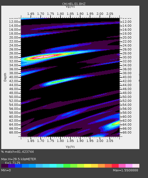
| Estimated Moho Depth: |
29.5 km |
| Estimated Crust Vp/Vs: |
1.71 |
| Assumed Crust Vp: |
6.566 km/s |
| Estimated Crust Vs: |
3.834 km/s |
| Estimated Crust Poisson's Ratio: |
0.24 |
|
| Radial Match: |
81.423744 % |
| Radial Bump: |
400 |
| Transverse Match: |
56.332607 % |
| Transverse Bump: |
400 |
| SOD ConfigId: |
1156111 |
| Insert Time: |
2015-10-08 08:23:25.601 +0000 |
| GWidth: |
2.5 |
| Max Bumps: |
400 |
| Tol: |
0.001 |
|

Signal To Noise
| Channel | StoN | STA | LTA |
| CM:HEL:01:BHZ:20150913T08:04:20.083005Z | 3.813408 | 4.3618272E-7 | 1.1438134E-7 |
| CM:HEL:01:BHN:20150913T08:04:20.083005Z | 1.1323309 | 1.3758124E-7 | 1.2150268E-7 |
| CM:HEL:01:BHE:20150913T08:04:20.083005Z | 5.366861 | 3.3006967E-7 | 6.150144E-8 |
| Arrivals |
| Ps | 3.5 SECOND |
| PpPs | 11 SECOND |
| PsPs/PpSs | 15 SECOND |


