You are here: Home > Network List > TJ - Tajikistan National Seismic Network Stations List
> Station GARM Garm, Tajikistan > Earthquake Result Viewer
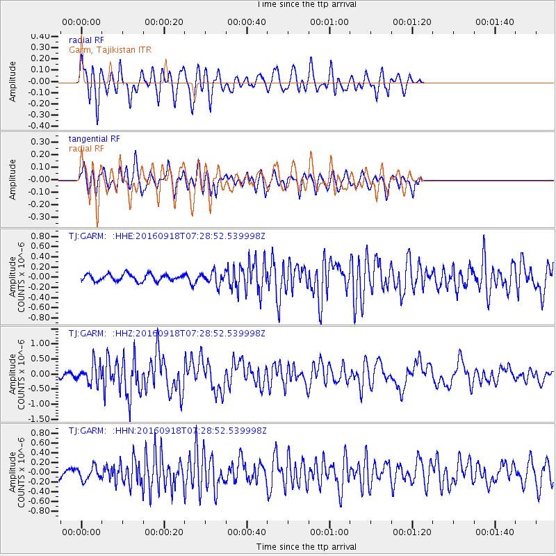
GARM Garm, Tajikistan - Earthquake Result Viewer
*The percent match for this event was below the threshold and hence no stack was calculated.
| Earthquake location: |
Near North Coast Of Irian Jaya |
| Earthquake latitude/longitude: |
-2.0/140.5 |
| Earthquake time(UTC): |
2016/09/18 (262) 07:17:36 GMT |
| Earthquake Depth: |
10 km |
| Earthquake Magnitude: |
5.5 MB |
| Earthquake Catalog/Contributor: |
NEIC PDE/NEIC COMCAT |
|
| Network: |
TJ Tajikistan National Seismic Network |
| Station: |
GARM Garm, Tajikistan |
| Lat/Lon: |
39.00 N/70.32 E |
| Elevation: |
1305 m |
|
| Distance: |
76.0 deg |
| Az: |
310.933 deg |
| Baz: |
104.316 deg |
| Ray Param: |
$rayparam |
*The percent match for this event was below the threshold and hence was not used in the summary stack. |
|
| Radial Match: |
78.682144 % |
| Radial Bump: |
400 |
| Transverse Match: |
69.217606 % |
| Transverse Bump: |
400 |
| SOD ConfigId: |
11737051 |
| Insert Time: |
2019-04-25 13:37:02.352 +0000 |
| GWidth: |
2.5 |
| Max Bumps: |
400 |
| Tol: |
0.001 |
|
Signal To Noise
| Channel | StoN | STA | LTA |
| TJ:GARM: :HHZ:20160918T07:28:52.539998Z | 2.270274 | 3.2380603E-7 | 1.4262861E-7 |
| TJ:GARM: :HHN:20160918T07:28:52.539998Z | 1.7346551 | 1.3434668E-7 | 7.744864E-8 |
| TJ:GARM: :HHE:20160918T07:28:52.539998Z | 1.8346169 | 1.2395041E-7 | 6.756201E-8 |
| Arrivals |
| Ps | |
| PpPs | |
| PsPs/PpSs | |


