You are here: Home > Network List > UW - Pacific Northwest Regional Seismic Network Stations List
> Station HOOD Mt Hood Meadows, OR CREST BB SMO > Earthquake Result Viewer
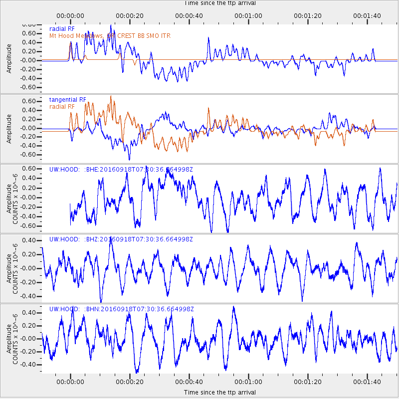
HOOD Mt Hood Meadows, OR CREST BB SMO - Earthquake Result Viewer
*The percent match for this event was below the threshold and hence no stack was calculated.
| Earthquake location: |
Near North Coast Of Irian Jaya |
| Earthquake latitude/longitude: |
-2.0/140.5 |
| Earthquake time(UTC): |
2016/09/18 (262) 07:17:36 GMT |
| Earthquake Depth: |
10 km |
| Earthquake Magnitude: |
5.5 MB |
| Earthquake Catalog/Contributor: |
NEIC PDE/NEIC COMCAT |
|
| Network: |
UW Pacific Northwest Regional Seismic Network |
| Station: |
HOOD Mt Hood Meadows, OR CREST BB SMO |
| Lat/Lon: |
45.32 N/121.65 W |
| Elevation: |
1520 m |
|
| Distance: |
97.0 deg |
| Az: |
44.754 deg |
| Baz: |
274.181 deg |
| Ray Param: |
$rayparam |
*The percent match for this event was below the threshold and hence was not used in the summary stack. |
|
| Radial Match: |
61.657032 % |
| Radial Bump: |
400 |
| Transverse Match: |
54.64326 % |
| Transverse Bump: |
400 |
| SOD ConfigId: |
11737051 |
| Insert Time: |
2019-04-25 13:37:16.684 +0000 |
| GWidth: |
2.5 |
| Max Bumps: |
400 |
| Tol: |
0.001 |
|
Signal To Noise
| Channel | StoN | STA | LTA |
| UW:HOOD: :BHZ:20160918T07:30:36.664998Z | 0.7290491 | 1.1999016E-7 | 1.6458448E-7 |
| UW:HOOD: :BHN:20160918T07:30:36.664998Z | 1.5492946 | 2.8802614E-7 | 1.8590792E-7 |
| UW:HOOD: :BHE:20160918T07:30:36.664998Z | 1.9384063 | 5.2254E-7 | 2.6957196E-7 |
| Arrivals |
| Ps | |
| PpPs | |
| PsPs/PpSs | |


