You are here: Home > Network List > ZQ15 - Taku Glacier Stations List
> Station GAGA Taku Glacier, Alaska, USA > Earthquake Result Viewer
GAGA Taku Glacier, Alaska, USA - Earthquake Result Viewer
| Earthquake location: |
Near North Coast Of Irian Jaya |
| Earthquake latitude/longitude: |
-2.0/140.5 |
| Earthquake time(UTC): |
2016/09/18 (262) 07:17:36 GMT |
| Earthquake Depth: |
10 km |
| Earthquake Magnitude: |
5.5 MB |
| Earthquake Catalog/Contributor: |
NEIC PDE/NEIC COMCAT |
|
| Network: |
ZQ Taku Glacier |
| Station: |
GAGA Taku Glacier, Alaska, USA |
| Lat/Lon: |
58.44 N/134.05 W |
| Elevation: |
258 m |
|
| Distance: |
89.3 deg |
| Az: |
31.624 deg |
| Baz: |
265.102 deg |
| Ray Param: |
0.0419277 |
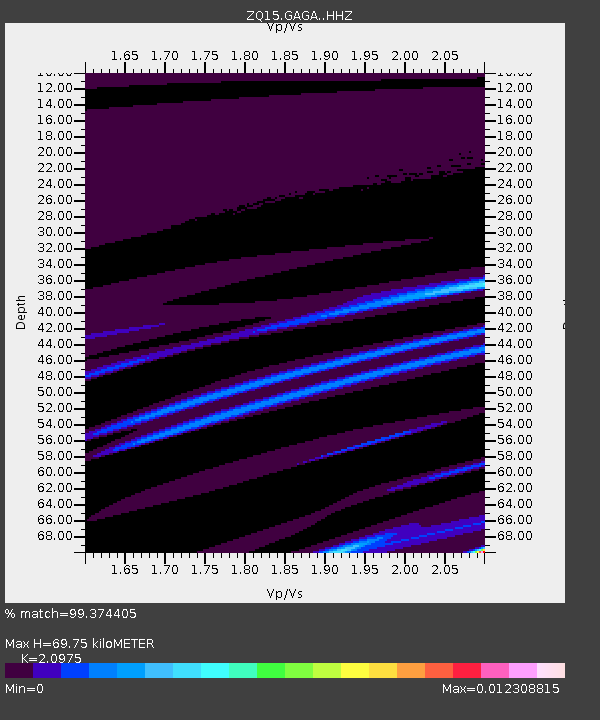
| Estimated Moho Depth: |
69.75 km |
| Estimated Crust Vp/Vs: |
2.10 |
| Assumed Crust Vp: |
6.566 km/s |
| Estimated Crust Vs: |
3.13 km/s |
| Estimated Crust Poisson's Ratio: |
0.35 |
|
| Radial Match: |
99.374405 % |
| Radial Bump: |
70 |
| Transverse Match: |
99.99974 % |
| Transverse Bump: |
2 |
| SOD ConfigId: |
11737051 |
| Insert Time: |
2019-04-25 13:37:52.845 +0000 |
| GWidth: |
2.5 |
| Max Bumps: |
400 |
| Tol: |
0.001 |
|

Signal To Noise
| Channel | StoN | STA | LTA |
| ZQ:GAGA: :HHZ:20160918T07:30:01.70998Z | 1.1164222 | 2.8666518E-6 | 2.5677132E-6 |
| ZQ:GAGA: :HH1:20160918T07:30:01.70998Z | 1.1148171 | 4.0668256E-6 | 3.647975E-6 |
| ZQ:GAGA: :HH2:20160918T07:30:01.70998Z | 0.84259564 | 4.6323176E-8 | 5.4976756E-8 |
| Arrivals |
| Ps | 12 SECOND |
| PpPs | 32 SECOND |
| PsPs/PpSs | 44 SECOND |


