You are here: Home > Network List > TA - USArray Transportable Network (new EarthScope stations) Stations List
> Station D25K Kavik River, AK, USA > Earthquake Result Viewer
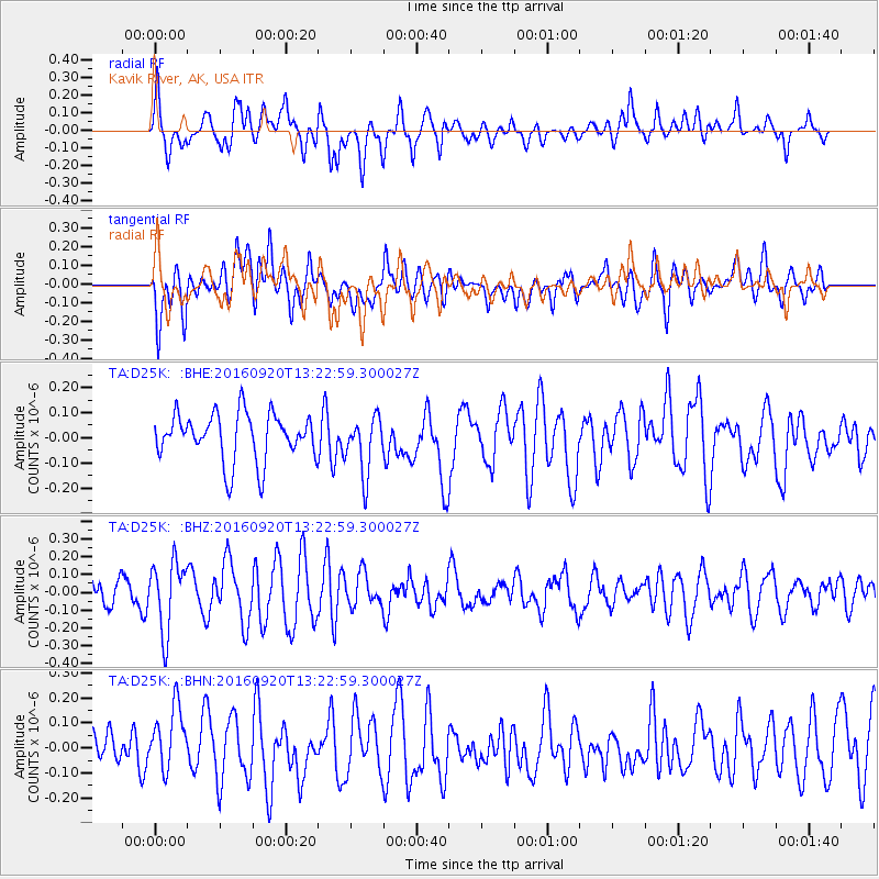
D25K Kavik River, AK, USA - Earthquake Result Viewer
*The percent match for this event was below the threshold and hence no stack was calculated.
| Earthquake location: |
Near North Coast Of Irian Jaya |
| Earthquake latitude/longitude: |
-2.0/138.7 |
| Earthquake time(UTC): |
2016/09/20 (264) 13:10:47 GMT |
| Earthquake Depth: |
10 km |
| Earthquake Magnitude: |
5.4 Mwb |
| Earthquake Catalog/Contributor: |
NEIC PDE/us |
|
| Network: |
TA USArray Transportable Network (new EarthScope stations) |
| Station: |
D25K Kavik River, AK, USA |
| Lat/Lon: |
69.32 N/146.38 W |
| Elevation: |
770 m |
|
| Distance: |
86.5 deg |
| Az: |
20.092 deg |
| Baz: |
255.144 deg |
| Ray Param: |
$rayparam |
*The percent match for this event was below the threshold and hence was not used in the summary stack. |
|
| Radial Match: |
67.63917 % |
| Radial Bump: |
400 |
| Transverse Match: |
47.254894 % |
| Transverse Bump: |
400 |
| SOD ConfigId: |
11737051 |
| Insert Time: |
2019-04-25 13:41:24.868 +0000 |
| GWidth: |
2.5 |
| Max Bumps: |
400 |
| Tol: |
0.001 |
|
Signal To Noise
| Channel | StoN | STA | LTA |
| TA:D25K: :BHZ:20160920T13:22:59.300027Z | 1.866862 | 1.9415742E-7 | 1.0400201E-7 |
| TA:D25K: :BHN:20160920T13:22:59.300027Z | 1.1919013 | 1.303636E-7 | 1.0937449E-7 |
| TA:D25K: :BHE:20160920T13:22:59.300027Z | 1.1935459 | 1.1313184E-7 | 9.478633E-8 |
| Arrivals |
| Ps | |
| PpPs | |
| PsPs/PpSs | |


