You are here: Home > Network List > AK - Alaska Regional Network Stations List
> Station SCM Sheep Mountain > Earthquake Result Viewer
SCM Sheep Mountain - Earthquake Result Viewer
| Earthquake location: |
Southeast Of Honshu, Japan |
| Earthquake latitude/longitude: |
30.5/142.1 |
| Earthquake time(UTC): |
2016/09/20 (264) 16:21:16 GMT |
| Earthquake Depth: |
10 km |
| Earthquake Magnitude: |
6.1 MWW, 6.0 MWB |
| Earthquake Catalog/Contributor: |
NEIC PDE/NEIC COMCAT |
|
| Network: |
AK Alaska Regional Network |
| Station: |
SCM Sheep Mountain |
| Lat/Lon: |
61.83 N/147.33 W |
| Elevation: |
1056 m |
|
| Distance: |
54.5 deg |
| Az: |
33.361 deg |
| Baz: |
269.125 deg |
| Ray Param: |
0.06542474 |
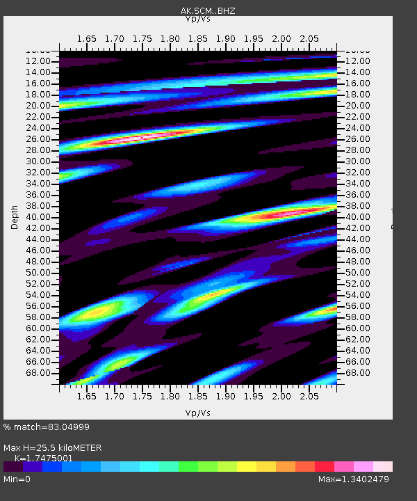
| Estimated Moho Depth: |
25.5 km |
| Estimated Crust Vp/Vs: |
1.75 |
| Assumed Crust Vp: |
6.566 km/s |
| Estimated Crust Vs: |
3.757 km/s |
| Estimated Crust Poisson's Ratio: |
0.26 |
|
| Radial Match: |
83.04999 % |
| Radial Bump: |
400 |
| Transverse Match: |
75.81183 % |
| Transverse Bump: |
400 |
| SOD ConfigId: |
11737051 |
| Insert Time: |
2019-04-25 13:44:46.214 +0000 |
| GWidth: |
2.5 |
| Max Bumps: |
400 |
| Tol: |
0.001 |
|

Signal To Noise
| Channel | StoN | STA | LTA |
| AK:SCM: :BHZ:20160920T16:30:13.607988Z | 9.426627 | 1.3532236E-6 | 1.4355331E-7 |
| AK:SCM: :BHN:20160920T16:30:13.607988Z | 1.4292487 | 2.7617287E-7 | 1.932294E-7 |
| AK:SCM: :BHE:20160920T16:30:13.607988Z | 3.5036175 | 5.9746947E-7 | 1.705293E-7 |
| Arrivals |
| Ps | 3.1 SECOND |
| PpPs | 10 SECOND |
| PsPs/PpSs | 13 SECOND |


