You are here: Home > Network List > CI - Caltech Regional Seismic Network Stations List
> Station PLM Palomar, California, USA > Earthquake Result Viewer
PLM Palomar, California, USA - Earthquake Result Viewer
| Earthquake location: |
Central Alaska |
| Earthquake latitude/longitude: |
63.5/-147.4 |
| Earthquake time(UTC): |
2002/11/03 (307) 22:12:41 GMT |
| Earthquake Depth: |
4.9 km |
| Earthquake Magnitude: |
7.0 MB, 8.5 MS, 7.9 MW |
| Earthquake Catalog/Contributor: |
WHDF/NEIC |
|
| Network: |
CI Caltech Regional Seismic Network |
| Station: |
PLM Palomar, California, USA |
| Lat/Lon: |
33.35 N/116.86 W |
| Elevation: |
1660 m |
|
| Distance: |
35.7 deg |
| Az: |
133.119 deg |
| Baz: |
336.984 deg |
| Ray Param: |
0.07710107 |
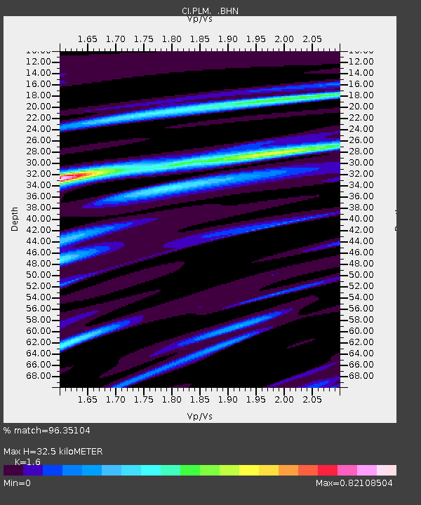
| Estimated Moho Depth: |
32.5 km |
| Estimated Crust Vp/Vs: |
1.60 |
| Assumed Crust Vp: |
6.264 km/s |
| Estimated Crust Vs: |
3.915 km/s |
| Estimated Crust Poisson's Ratio: |
0.18 |
|
| Radial Match: |
96.35104 % |
| Radial Bump: |
240 |
| Transverse Match: |
78.23755 % |
| Transverse Bump: |
400 |
| SOD ConfigId: |
4714 |
| Insert Time: |
2010-02-26 00:44:57.292 +0000 |
| GWidth: |
2.5 |
| Max Bumps: |
400 |
| Tol: |
0.001 |
|

Signal To Noise
| Channel | StoN | STA | LTA |
| CI:PLM: :BHN:20021103T22:19:09.403015Z | 8.073323 | 2.083707E-6 | 2.580978E-7 |
| CI:PLM: :BHE:20021103T22:19:09.403015Z | 5.3410587 | 7.926697E-7 | 1.484106E-7 |
| CI:PLM: :BHZ:20021103T22:19:09.403015Z | 10.4101925 | 3.0766907E-6 | 2.95546E-7 |
| Arrivals |
| Ps | 3.4 SECOND |
| PpPs | 12 SECOND |
| PsPs/PpSs | 16 SECOND |


