You are here: Home > Network List > NY - Yukon Northwest Seismic Network(YNSN) Stations List
> Station MMPY Sheldon Lake, Yukon, CANADA > Earthquake Result Viewer
MMPY Sheldon Lake, Yukon, CANADA - Earthquake Result Viewer
| Earthquake location: |
Southeast Of Honshu, Japan |
| Earthquake latitude/longitude: |
30.5/142.1 |
| Earthquake time(UTC): |
2016/09/20 (264) 16:21:16 GMT |
| Earthquake Depth: |
10 km |
| Earthquake Magnitude: |
6.1 MWW, 6.0 MWB |
| Earthquake Catalog/Contributor: |
NEIC PDE/NEIC COMCAT |
|
| Network: |
NY Yukon Northwest Seismic Network(YNSN) |
| Station: |
MMPY Sheldon Lake, Yukon, CANADA |
| Lat/Lon: |
62.62 N/131.26 W |
| Elevation: |
0.0 m |
|
| Distance: |
61.9 deg |
| Az: |
31.561 deg |
| Baz: |
282.386 deg |
| Ray Param: |
0.060602177 |
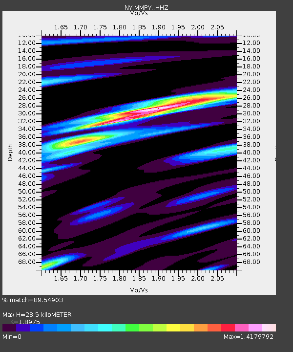
| Estimated Moho Depth: |
28.5 km |
| Estimated Crust Vp/Vs: |
1.90 |
| Assumed Crust Vp: |
6.419 km/s |
| Estimated Crust Vs: |
3.383 km/s |
| Estimated Crust Poisson's Ratio: |
0.31 |
|
| Radial Match: |
89.54903 % |
| Radial Bump: |
371 |
| Transverse Match: |
89.50206 % |
| Transverse Bump: |
365 |
| SOD ConfigId: |
11737051 |
| Insert Time: |
2019-04-25 13:50:17.369 +0000 |
| GWidth: |
2.5 |
| Max Bumps: |
400 |
| Tol: |
0.001 |
|

Signal To Noise
| Channel | StoN | STA | LTA |
| NY:MMPY: :HHZ:20160920T16:31:05.209978Z | 8.578803 | 9.421293E-7 | 1.098206E-7 |
| NY:MMPY: :HHN:20160920T16:31:05.209978Z | 0.9585393 | 6.309287E-10 | 6.582189E-10 |
| NY:MMPY: :HHE:20160920T16:31:05.209978Z | 5.3351817 | 4.0964431E-7 | 7.6781696E-8 |
| Arrivals |
| Ps | 4.2 SECOND |
| PpPs | 12 SECOND |
| PsPs/PpSs | 16 SECOND |


