You are here: Home > Network List > US - United States National Seismic Network Stations List
> Station WVT Waverly, Tennessee, USA > Earthquake Result Viewer
WVT Waverly, Tennessee, USA - Earthquake Result Viewer
| Earthquake location: |
Chile-Bolivia Border Region |
| Earthquake latitude/longitude: |
-22.3/-67.9 |
| Earthquake time(UTC): |
2005/11/17 (321) 19:26:56 GMT |
| Earthquake Depth: |
163 km |
| Earthquake Magnitude: |
6.0 MB, 6.9 MW, 6.8 MW |
| Earthquake Catalog/Contributor: |
WHDF/NEIC |
|
| Network: |
US United States National Seismic Network |
| Station: |
WVT Waverly, Tennessee, USA |
| Lat/Lon: |
36.13 N/87.83 W |
| Elevation: |
153 m |
|
| Distance: |
61.1 deg |
| Az: |
341.618 deg |
| Baz: |
158.856 deg |
| Ray Param: |
0.060595598 |
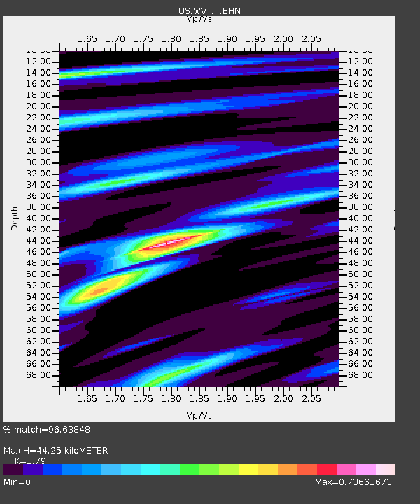
| Estimated Moho Depth: |
44.25 km |
| Estimated Crust Vp/Vs: |
1.79 |
| Assumed Crust Vp: |
6.444 km/s |
| Estimated Crust Vs: |
3.6 km/s |
| Estimated Crust Poisson's Ratio: |
0.27 |
|
| Radial Match: |
96.63848 % |
| Radial Bump: |
300 |
| Transverse Match: |
90.57082 % |
| Transverse Bump: |
400 |
| SOD ConfigId: |
2422 |
| Insert Time: |
2010-03-05 07:07:20.803 +0000 |
| GWidth: |
2.5 |
| Max Bumps: |
400 |
| Tol: |
0.001 |
|

Signal To Noise
| Channel | StoN | STA | LTA |
| US:WVT: :BHN:20051117T19:36:22.695015Z | 29.767334 | 5.267264E-6 | 1.7694778E-7 |
| US:WVT: :BHE:20051117T19:36:22.695015Z | 15.704716 | 2.8429465E-6 | 1.8102503E-7 |
| US:WVT: :BHZ:20051117T19:36:22.695015Z | 64.17748 | 1.2822021E-5 | 1.9979004E-7 |
| Arrivals |
| Ps | 5.7 SECOND |
| PpPs | 18 SECOND |
| PsPs/PpSs | 24 SECOND |


