You are here: Home > Network List > TA - USArray Transportable Network (new EarthScope stations) Stations List
> Station F22K John River, AK, USA > Earthquake Result Viewer
F22K John River, AK, USA - Earthquake Result Viewer
| Earthquake location: |
Southeast Of Honshu, Japan |
| Earthquake latitude/longitude: |
30.5/142.1 |
| Earthquake time(UTC): |
2016/09/20 (264) 16:21:16 GMT |
| Earthquake Depth: |
10 km |
| Earthquake Magnitude: |
6.1 MWW, 6.0 MWB |
| Earthquake Catalog/Contributor: |
NEIC PDE/NEIC COMCAT |
|
| Network: |
TA USArray Transportable Network (new EarthScope stations) |
| Station: |
F22K John River, AK, USA |
| Lat/Lon: |
67.51 N/152.18 W |
| Elevation: |
546 m |
|
| Distance: |
52.9 deg |
| Az: |
26.087 deg |
| Baz: |
260.427 deg |
| Ray Param: |
0.06645254 |
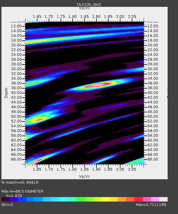
| Estimated Moho Depth: |
69.5 km |
| Estimated Crust Vp/Vs: |
1.62 |
| Assumed Crust Vp: |
6.455 km/s |
| Estimated Crust Vs: |
3.972 km/s |
| Estimated Crust Poisson's Ratio: |
0.20 |
|
| Radial Match: |
81.98619 % |
| Radial Bump: |
400 |
| Transverse Match: |
69.63973 % |
| Transverse Bump: |
400 |
| SOD ConfigId: |
11737051 |
| Insert Time: |
2019-04-25 13:51:54.578 +0000 |
| GWidth: |
2.5 |
| Max Bumps: |
400 |
| Tol: |
0.001 |
|

Signal To Noise
| Channel | StoN | STA | LTA |
| TA:F22K: :BHZ:20160920T16:30:02.200029Z | 5.7449927 | 8.262448E-7 | 1.4381997E-7 |
| TA:F22K: :BHN:20160920T16:30:02.200029Z | 0.96375227 | 1.5280284E-7 | 1.5854991E-7 |
| TA:F22K: :BHE:20160920T16:30:02.200029Z | 4.3469605 | 3.0618702E-7 | 7.043703E-8 |
| Arrivals |
| Ps | 7.1 SECOND |
| PpPs | 27 SECOND |
| PsPs/PpSs | 34 SECOND |


