You are here: Home > Network List > TA - USArray Transportable Network (new EarthScope stations) Stations List
> Station F31M Tsiigehtchic, NWT, CAN > Earthquake Result Viewer
F31M Tsiigehtchic, NWT, CAN - Earthquake Result Viewer
| Earthquake location: |
Southeast Of Honshu, Japan |
| Earthquake latitude/longitude: |
30.5/142.1 |
| Earthquake time(UTC): |
2016/09/20 (264) 16:21:16 GMT |
| Earthquake Depth: |
10 km |
| Earthquake Magnitude: |
6.1 MWW, 6.0 MWB |
| Earthquake Catalog/Contributor: |
NEIC PDE/NEIC COMCAT |
|
| Network: |
TA USArray Transportable Network (new EarthScope stations) |
| Station: |
F31M Tsiigehtchic, NWT, CAN |
| Lat/Lon: |
67.44 N/133.74 W |
| Elevation: |
56 m |
|
| Distance: |
60.0 deg |
| Az: |
26.314 deg |
| Baz: |
277.588 deg |
| Ray Param: |
0.061828203 |
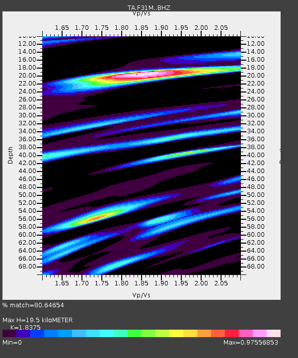
| Estimated Moho Depth: |
19.5 km |
| Estimated Crust Vp/Vs: |
1.84 |
| Assumed Crust Vp: |
6.171 km/s |
| Estimated Crust Vs: |
3.359 km/s |
| Estimated Crust Poisson's Ratio: |
0.29 |
|
| Radial Match: |
80.64654 % |
| Radial Bump: |
400 |
| Transverse Match: |
63.768055 % |
| Transverse Bump: |
400 |
| SOD ConfigId: |
11737051 |
| Insert Time: |
2019-04-25 13:51:57.147 +0000 |
| GWidth: |
2.5 |
| Max Bumps: |
400 |
| Tol: |
0.001 |
|
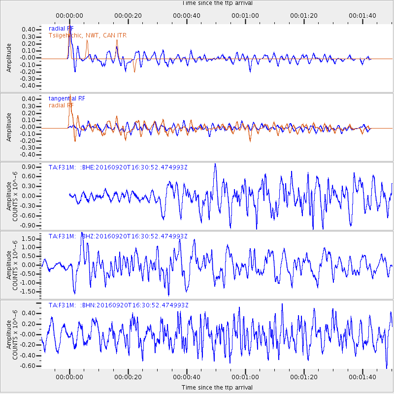
Signal To Noise
| Channel | StoN | STA | LTA |
| TA:F31M: :BHZ:20160920T16:30:52.474993Z | 6.146364 | 9.104731E-7 | 1.4813197E-7 |
| TA:F31M: :BHN:20160920T16:30:52.474993Z | 0.9549343 | 1.382666E-7 | 1.4479174E-7 |
| TA:F31M: :BHE:20160920T16:30:52.474993Z | 3.573648 | 3.5814696E-7 | 1.0021887E-7 |
| Arrivals |
| Ps | 2.8 SECOND |
| PpPs | 8.6 SECOND |
| PsPs/PpSs | 11 SECOND |


