You are here: Home > Network List > TA - USArray Transportable Network (new EarthScope stations) Stations List
> Station H21K Melozitna River, AK, USA > Earthquake Result Viewer
H21K Melozitna River, AK, USA - Earthquake Result Viewer
| Earthquake location: |
Southeast Of Honshu, Japan |
| Earthquake latitude/longitude: |
30.5/142.1 |
| Earthquake time(UTC): |
2016/09/20 (264) 16:21:16 GMT |
| Earthquake Depth: |
10 km |
| Earthquake Magnitude: |
6.1 MWW, 6.0 MWB |
| Earthquake Catalog/Contributor: |
NEIC PDE/NEIC COMCAT |
|
| Network: |
TA USArray Transportable Network (new EarthScope stations) |
| Station: |
H21K Melozitna River, AK, USA |
| Lat/Lon: |
65.66 N/152.80 W |
| Elevation: |
520 m |
|
| Distance: |
52.4 deg |
| Az: |
28.346 deg |
| Baz: |
261.224 deg |
| Ray Param: |
0.066803746 |
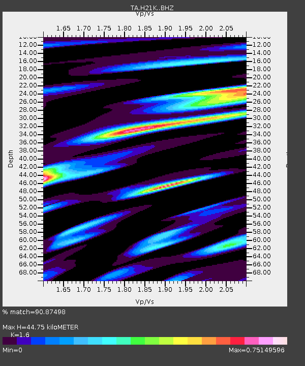
| Estimated Moho Depth: |
44.75 km |
| Estimated Crust Vp/Vs: |
1.60 |
| Assumed Crust Vp: |
6.566 km/s |
| Estimated Crust Vs: |
4.104 km/s |
| Estimated Crust Poisson's Ratio: |
0.18 |
|
| Radial Match: |
90.87498 % |
| Radial Bump: |
354 |
| Transverse Match: |
72.90326 % |
| Transverse Bump: |
400 |
| SOD ConfigId: |
11737051 |
| Insert Time: |
2019-04-25 13:52:04.815 +0000 |
| GWidth: |
2.5 |
| Max Bumps: |
400 |
| Tol: |
0.001 |
|

Signal To Noise
| Channel | StoN | STA | LTA |
| TA:H21K: :BHZ:20160920T16:29:58.175005Z | 10.942799 | 1.0882229E-6 | 9.944648E-8 |
| TA:H21K: :BHN:20160920T16:29:58.175005Z | 1.0996288 | 2.6665225E-7 | 2.4249297E-7 |
| TA:H21K: :BHE:20160920T16:29:58.175005Z | 4.7409267 | 6.484429E-7 | 1.3677555E-7 |
| Arrivals |
| Ps | 4.4 SECOND |
| PpPs | 17 SECOND |
| PsPs/PpSs | 21 SECOND |


