You are here: Home > Network List > US - United States National Seismic Network Stations List
> Station WVT Waverly, Tennessee, USA > Earthquake Result Viewer
WVT Waverly, Tennessee, USA - Earthquake Result Viewer
| Earthquake location: |
Kuril Islands |
| Earthquake latitude/longitude: |
46.5/153.2 |
| Earthquake time(UTC): |
2006/10/01 (274) 09:06:02 GMT |
| Earthquake Depth: |
19 km |
| Earthquake Magnitude: |
6.1 MB, 6.4 MS, 6.6 MW, 6.5 MW |
| Earthquake Catalog/Contributor: |
WHDF/NEIC |
|
| Network: |
US United States National Seismic Network |
| Station: |
WVT Waverly, Tennessee, USA |
| Lat/Lon: |
36.13 N/87.83 W |
| Elevation: |
153 m |
|
| Distance: |
81.2 deg |
| Az: |
45.811 deg |
| Baz: |
322.253 deg |
| Ray Param: |
0.047761563 |
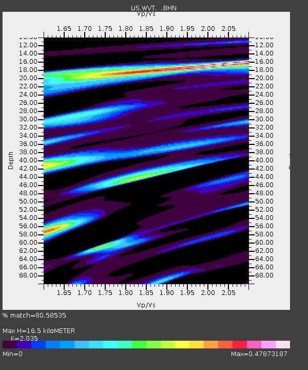
| Estimated Moho Depth: |
16.5 km |
| Estimated Crust Vp/Vs: |
2.04 |
| Assumed Crust Vp: |
6.444 km/s |
| Estimated Crust Vs: |
3.167 km/s |
| Estimated Crust Poisson's Ratio: |
0.34 |
|
| Radial Match: |
80.58535 % |
| Radial Bump: |
389 |
| Transverse Match: |
64.01756 % |
| Transverse Bump: |
400 |
| SOD ConfigId: |
2665 |
| Insert Time: |
2010-03-05 07:07:32.005 +0000 |
| GWidth: |
2.5 |
| Max Bumps: |
400 |
| Tol: |
0.001 |
|

Signal To Noise
| Channel | StoN | STA | LTA |
| US:WVT: :BHN:20061001T09:17:45.186028Z | 1.38908 | 2.6137076E-7 | 1.8816105E-7 |
| US:WVT: :BHE:20061001T09:17:45.186028Z | 2.0110588 | 3.850916E-7 | 1.9148699E-7 |
| US:WVT: :BHZ:20061001T09:17:45.186028Z | 6.092334 | 1.1378174E-6 | 1.8676215E-7 |
| Arrivals |
| Ps | 2.7 SECOND |
| PpPs | 7.6 SECOND |
| PsPs/PpSs | 10 SECOND |


