You are here: Home > Network List > TA - USArray Transportable Network (new EarthScope stations) Stations List
> Station M30M Minto, Yukon, CA > Earthquake Result Viewer
M30M Minto, Yukon, CA - Earthquake Result Viewer
| Earthquake location: |
Southeast Of Honshu, Japan |
| Earthquake latitude/longitude: |
30.5/142.1 |
| Earthquake time(UTC): |
2016/09/20 (264) 16:21:16 GMT |
| Earthquake Depth: |
10 km |
| Earthquake Magnitude: |
6.1 MWW, 6.0 MWB |
| Earthquake Catalog/Contributor: |
NEIC PDE/NEIC COMCAT |
|
| Network: |
TA USArray Transportable Network (new EarthScope stations) |
| Station: |
M30M Minto, Yukon, CA |
| Lat/Lon: |
62.58 N/136.79 W |
| Elevation: |
782 m |
|
| Distance: |
59.4 deg |
| Az: |
32.122 deg |
| Baz: |
277.758 deg |
| Ray Param: |
0.062243886 |
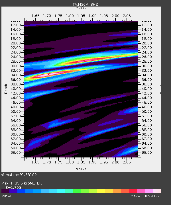
| Estimated Moho Depth: |
33.5 km |
| Estimated Crust Vp/Vs: |
1.71 |
| Assumed Crust Vp: |
6.566 km/s |
| Estimated Crust Vs: |
3.851 km/s |
| Estimated Crust Poisson's Ratio: |
0.24 |
|
| Radial Match: |
91.58192 % |
| Radial Bump: |
400 |
| Transverse Match: |
71.001625 % |
| Transverse Bump: |
400 |
| SOD ConfigId: |
11737051 |
| Insert Time: |
2019-04-25 13:52:39.383 +0000 |
| GWidth: |
2.5 |
| Max Bumps: |
400 |
| Tol: |
0.001 |
|

Signal To Noise
| Channel | StoN | STA | LTA |
| TA:M30M: :BHZ:20160920T16:30:48.125017Z | 9.596635 | 1.0153606E-6 | 1.0580381E-7 |
| TA:M30M: :BHN:20160920T16:30:48.125017Z | 1.6808559 | 1.9341073E-7 | 1.1506682E-7 |
| TA:M30M: :BHE:20160920T16:30:48.125017Z | 8.134271 | 4.81892E-7 | 5.9242186E-8 |
| Arrivals |
| Ps | 3.8 SECOND |
| PpPs | 13 SECOND |
| PsPs/PpSs | 17 SECOND |


