You are here: Home > Network List > TA - USArray Transportable Network (new EarthScope stations) Stations List
> Station O17K Koliganek, Bristol Bay, AK, USA > Earthquake Result Viewer
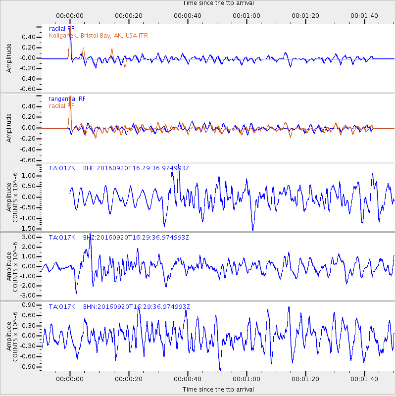
O17K Koliganek, Bristol Bay, AK, USA - Earthquake Result Viewer
*The percent match for this event was below the threshold and hence no stack was calculated.
| Earthquake location: |
Southeast Of Honshu, Japan |
| Earthquake latitude/longitude: |
30.5/142.1 |
| Earthquake time(UTC): |
2016/09/20 (264) 16:21:16 GMT |
| Earthquake Depth: |
10 km |
| Earthquake Magnitude: |
6.1 MWW, 6.0 MWB |
| Earthquake Catalog/Contributor: |
NEIC PDE/NEIC COMCAT |
|
| Network: |
TA USArray Transportable Network (new EarthScope stations) |
| Station: |
O17K Koliganek, Bristol Bay, AK, USA |
| Lat/Lon: |
59.77 N/157.09 W |
| Elevation: |
156 m |
|
| Distance: |
49.5 deg |
| Az: |
35.492 deg |
| Baz: |
261.918 deg |
| Ray Param: |
$rayparam |
*The percent match for this event was below the threshold and hence was not used in the summary stack. |
|
| Radial Match: |
69.656845 % |
| Radial Bump: |
400 |
| Transverse Match: |
53.853844 % |
| Transverse Bump: |
400 |
| SOD ConfigId: |
11737051 |
| Insert Time: |
2019-04-25 13:52:50.655 +0000 |
| GWidth: |
2.5 |
| Max Bumps: |
400 |
| Tol: |
0.001 |
|
Signal To Noise
| Channel | StoN | STA | LTA |
| TA:O17K: :BHZ:20160920T16:29:36.974993Z | 2.9162307 | 9.935164E-7 | 3.4068512E-7 |
| TA:O17K: :BHN:20160920T16:29:36.974993Z | 1.2095832 | 3.0883174E-7 | 2.553208E-7 |
| TA:O17K: :BHE:20160920T16:29:36.974993Z | 2.0141485 | 6.2376216E-7 | 3.0969025E-7 |
| Arrivals |
| Ps | |
| PpPs | |
| PsPs/PpSs | |


