You are here: Home > Network List > TA - USArray Transportable Network (new EarthScope stations) Stations List
> Station TCOL CIGO, UAF Yankovich Road, Fairbanks, AK, USA > Earthquake Result Viewer
TCOL CIGO, UAF Yankovich Road, Fairbanks, AK, USA - Earthquake Result Viewer
| Earthquake location: |
Southeast Of Honshu, Japan |
| Earthquake latitude/longitude: |
30.5/142.1 |
| Earthquake time(UTC): |
2016/09/20 (264) 16:21:16 GMT |
| Earthquake Depth: |
10 km |
| Earthquake Magnitude: |
6.1 MWW, 6.0 MWB |
| Earthquake Catalog/Contributor: |
NEIC PDE/NEIC COMCAT |
|
| Network: |
TA USArray Transportable Network (new EarthScope stations) |
| Station: |
TCOL CIGO, UAF Yankovich Road, Fairbanks, AK, USA |
| Lat/Lon: |
64.87 N/147.86 W |
| Elevation: |
178 m |
|
| Distance: |
54.4 deg |
| Az: |
29.598 deg |
| Baz: |
266.456 deg |
| Ray Param: |
0.065501794 |
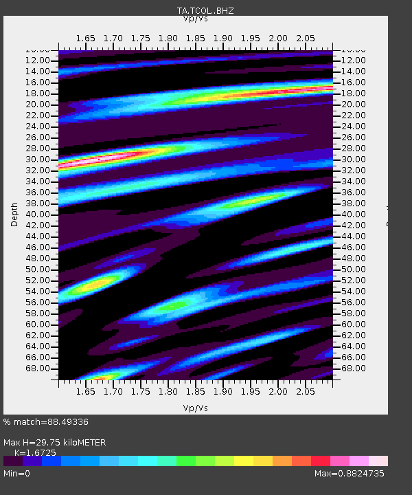
| Estimated Moho Depth: |
29.75 km |
| Estimated Crust Vp/Vs: |
1.67 |
| Assumed Crust Vp: |
6.566 km/s |
| Estimated Crust Vs: |
3.926 km/s |
| Estimated Crust Poisson's Ratio: |
0.22 |
|
| Radial Match: |
88.49336 % |
| Radial Bump: |
400 |
| Transverse Match: |
57.596935 % |
| Transverse Bump: |
400 |
| SOD ConfigId: |
11737051 |
| Insert Time: |
2019-04-25 13:53:16.856 +0000 |
| GWidth: |
2.5 |
| Max Bumps: |
400 |
| Tol: |
0.001 |
|

Signal To Noise
| Channel | StoN | STA | LTA |
| TA:TCOL: :BHZ:20160920T16:30:12.724993Z | 10.204114 | 1.3875591E-6 | 1.3598037E-7 |
| TA:TCOL: :BHN:20160920T16:30:12.724993Z | 1.2032784 | 3.1874353E-7 | 2.648959E-7 |
| TA:TCOL: :BHE:20160920T16:30:12.724993Z | 3.060376 | 6.8210966E-7 | 2.2288427E-7 |
| Arrivals |
| Ps | 3.2 SECOND |
| PpPs | 11 SECOND |
| PsPs/PpSs | 15 SECOND |


